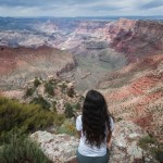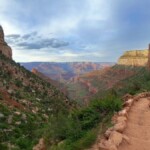
Hiking the Grand Canyon South Rim is one of those things you simply cannot miss. With numerous breathtaking views and an array of trails that cater to both seasoned hikers and casual explorers, you’ll have no excuse to miss out on this great adventure.
Some of the trails descend part or all of the way to the Colorado River, so they require special preparation and a day or two to complete. Still, you can enjoy a nice hike into the Grand Canyon South Rim without having to complete the entire trail or just stick to the easier above-the-rim trails. In any case, if your main goal is hiking, I recommend visiting during the spring and fall, which is considered the best time for visiting the Grand Canyon anyway.
We have hiked in the Grand Canyon many times, and my favorite months are May, June, September and October. However, one year we visited in August and hiking in the South Rim was a nightmare, so I really recommend planning your visit accordingly.
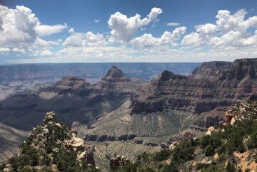
In terms of difficulty, you can find everything from easy to strenuous hikes in the South Rim, but each one offers a unique adventure and a chance to connect with nature. In this guide, I will share my top South Rim hikes along with some useful information to help you plan your own hikes.
1. Grand Canyon Rim Trail, one of the most popular hikes at the Grand Canyon South Rim
The Grand Canyon Rim Trail is a beautiful and easily accessible trail, perfect for anyone visiting the South Rim for the first time. Stretching over 12.5 miles along the edge of the Grand Canyon, this trail offers one of the best hikes in the South Rim. It’s a great choice for hikers of all levels due to its mostly flat and paved terrain, so everyone in the family can enjoy the adventure.
The trail runs from the South Kaibab Trailhead in the east to Hermits Rest in the west, passing through numerous popular viewpoints in the Grand Canyon like Yavapai Point and Hopi Point. If you’re interested in a more leisurely and educational experience, keep an eye out for interpretive signs along the way that provide insights into the geology, history, and ecology of the Grand Canyon.

1. Grand Canyon Rim Trail, one of the most popular hikes at the Grand Canyon South Rim
Remember, hiking the entire trail may be difficult due to its length, but you can hop on the free shuttle buses in the village at any point to explore different sections at your own pace. The most popular segment of the trail goes from Mather Point to Yavapai Point, commonly known as the “Trail of Time.”
Keep in mind that water is only available at a few places along the trail, such as Hermit’s Rest, Bright Angel Trailhead, within Grand Canyon Village, and the South Kaibab Trailhead. So, plan accordingly to enjoy a memorable hike in the Grand Canyon South Rim.
- Duration: 4-5 hours
- Distance: 12.7 miles
- Difficulty: Easy to Moderate (depending on whether you’re hiking just a section or the whole thing)
- When to go: Year-round
- Route type: One-way
- Obstacles: Mostly paved and well-maintained, but can be crowded in popular sections
- Elevation change: 583 ft
2. Bright Angel Trail, one of the oldest hiking trails in the South Rim of the Grand Canyon
The Bright Angel Trail is one of the most scenic hikes in the Grand Canyon South Rim. However, I only recommend it to experienced hikers, since it descends approximately 4,500 feet from the South Rim to the Colorado River, stretching nearly 8 miles.
For that reason, most visitors hike just a section, turning around at one of the two Rest Houses (1.5 miles and 3 miles from the trailhead), at the Havasupai Gardens campground (4.5 miles from the trailhead), or at Plateau Point (that is a 1.5-mile detour from Havasupai Gardens).
With well-maintained paths, frequent rest stops, and multiple water stations along the way, the trail provides a great opportunity to explore the canyon. Plus, the Rest Houses offer shaded shelters, toilets, and emergency phones.

2. Bright Angel Trail, one of the oldest hiking trails in the South Rim of the Grand Canyon
If you’re planning to go all the way down to the Colorado River, you should avoid hiking the trail during the summer months due to the extreme temperatures and strenuous conditions. I also recommend splitting this hike into two days: descending to the river on the first day, and ascending back to the rim on the second day.
In our case, we hiked this trail during our rim-to-rim adventure and we found it really strenuous, especially on the way back. And mind you, we took 3 days to complete the hike.
Just take into account that you will need to get a backcountry permit ahead of time if you’re planning to do a multi-day camping trip. Another option is to spend the night at Phantom Ranch, but you need to submit your request for the lottery 15 months in advance!
- Duration: 4-5 hours going down and 7-8 hours going up
- Distance: 8 miles (one-way)
- Difficulty: Strenuous
- When to go: Better in spring and fall
- Route type: Can be combined with the North Kaibab Trail to hike rim-to-rim or used as an out-and-back trail
- Obstacles: Long distance, steep ascent on the way back and potential hazards like severe weather, overexertion, and dehydration
- Elevation change: 4,478 ft
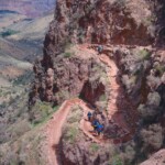
3. South Kaibab Trail, one of the most difficult hikes in the Grand Canyon South Rim
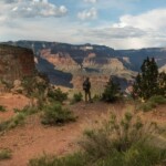
The South Kaibab Trail is one of the most challenging hikes in the Grand Canyon South Rim. This trail also takes you all the way down to the Colorado River, but compared to the Bright Angel Trail, it’s much more rugged, with no shaded sections or water stops. However, it offers unparalleled views of the canyon, making it ideal for seasoned desert hikers. Plus, it’s usually less crowded, so you can enjoy a peaceful hike.
You’ll find the trailhead near Yaki Point, which is only accessible via the Kaibab Rim (Orange) Route shuttle bus from Grand Canyon Village. Trust me, it’s worth it!
The trail descends steeply into the canyon, covering about 7 miles one-way. There are several popular stopping points where you can turn around if you don’t want to do the full hike, including Ooh Aah Point (approximately 0.9 miles from the trailhead), Cedar Ridge (about 1.3 miles from the trailhead), and Skeleton Point (about 2.8 miles from the trailhead).

3. South Kaibab Trail, one of the most difficult hikes in the Grand Canyon South Rim
If you’re planning to go all the way to the Colorado River, consider staying overnight at Phantom Ranch or Bright Angel Campground. Most hikers head back up via the Bright Angel Trail, since it’s not as steep and has more shade and spots to rest.
Summer hikes here can be tough due to the heat and lack of water. Instead, you can try it during cooler months, and start your journey early in the morning to avoid the risk of heat-related illnesses. I also wouldn’t recommend attempting to hike down to the river and back in one day. It’s typically considered a multi-day hike in the Grand Canyon South Rim, so take your time and enjoy the journey.
My favorite thing about this scenic hike in the South Rim was the opportunity to observe animals in the Grand Canyon, including mule deer, bighorn sheep, and condors. So, keep an eye out!
- Duration: 4-5 hours going down and 7-8 hours going up
- Distance: 6.8 miles (one-way)
- Difficulty: Strenuous
- When to go: Spring and fall
- Route type: Can be combined with the North Kaibab Trail to hike rim-to-rim or used as an out-and-back trail
- Obstacles: Long distance, very little shade, steep ascent on the way back and potential hazards like severe weather, overexertion, dehydration and wildlife encounters
- Elevation change: 4,734 ft
4. Hermit Trail, a Grand Canyon South Rim hike with stunning viewpoints
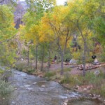
The Hermit Trail is one of the lesser-known but incredibly beautiful hikes in the Grand Canyon South Rim, which offers a more rugged experience compared to the more popular trails. You can access the trailhead via the Hermit (Red) Route shuttle from Grand Canyon Village. The shuttle operates from March 1 to November 30, with the first bus leaving at 8:00 am and the last outbound bus departing the Village at 7:00 pm. The ride takes about an hour. In winter, when the shuttle isn’t running, you can drive yourself—just keep in mind that the road may be closed due to snow and ice.
The Hermit Trail is quite an adventure, featuring a variety of terrains, from steep switchbacks to narrow ledges. You’ll descend 1,800 feet in the first 2.5 miles, passing through the striking Kaibab Formation and Coconino Sandstone. That’s why this hike in the Grand Canyon South Rim is best suited for experienced hikers.

4. Hermit Trail, a Grand Canyon South Rim hike with stunning viewpoints
If you’re not up for the entire trail, no worries! You can turn back at several points along the way. Waldron Basin is 1.2 miles in, Santa Maria Spring is 2.5 miles in, and Lookout Point is about 4 miles from the trailhead. Just remember, don’t drink water directly from the springs unless you purify it first.
For camping, you have two options: Hermit Creek (BM7), which has toilets, and Hermit Rapids (BM8). Don’t forget, you’ll need a backcountry permit for any camping below the rim. We didn’t have enough time to make it to Hermit Rapids, so we turned around at Lookout Point. Even so, it was one of my favorite hikes in the South Rim of the Grand Canyon.
- Duration: 4-5 hours going down and 6-7 hours going up
- Distance: 8.5 miles (one-way)
- Difficulty: Strenuous
- When to go: Spring and fall
- Route type: Out-and-back
- Obstacles: Long distance, rocky, some scrambling, very little shade
- Elevation change: 5,013 ft
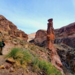
5. Grandview Trail, one of the best hikes at the Grand Canyon South Rim
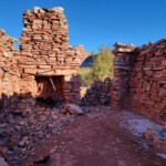
The Grandview Trail offers a challenging hike in the Grand Canyon South Rim with stunning panoramic views. This trail was originally built in the 1890s by miner Pete Berry for mining operations, but it later became popular with tourists. You’ll still see remnants of old mining operations along the trail—just remember not to touch or move anything to help preserve its history.
The trailhead is located at Grandview Point, one of the most spectacular viewpoints in the South Rim. There’s no shuttle bus to get there, so you’ll need to drive about 15 minutes from the Village, park your car, and start your hike from there. The trail features steep slopes and eroded sections, so be extra cautious, especially in winter when it can be icy or wet.

5. Grandview Trail, one of the best hikes at the Grand Canyon South Rim
The trail descends roughly 2,600 feet, passing through the Coconino Sandstone and Hermit Shale formations. If you don’t want to do the full hike, you can turn around at Coconino Saddle, which is about 1 mile from the trailhead. However, I recommend pushing on to Horseshoe Mesa if you can, where you are allowed to camp with a backcountry permit. Beyond Horseshoe Mesa, the trail splits into routes leading to Cottonwood Creek and Hance Creek, both of which allow at-large camping.
If you’re not interested in camping, with proper preparation, this can be your day hike in the Grand Canyon South Rim. Start early to avoid the midday heat and carry plenty of water, because there are no reliable water sources between the rim and Horseshoe Mesa.
- Duration: 5-6 hours
- Distance: 5.6 miles
- Difficulty: Hard
- When to go: Spring and fall
- Route type: Out-and-back
- Obstacles: Long distance, rocky, some scrambling, no shade
- Elevation change: 2,526 ft
6. Tanner Trail, the best trail at the Grand Canyon South Rim for experienced hikers
The Tanner Trail is definitely one of the most difficult trails in the Grand Canyon South Rim, spanning over 7 miles from Lipan Point to Tanner Rapids at the Colorado River, with a roughly 5,400-foot elevation change. It’s a long and challenging trail, so I wouldn’t recommend it as a day hike. Instead, it’s a great choice for a multi-day backpacking trip, during which you’ll have plenty of time to enjoy landmarks like Escalante Butte and Cardenas Butte along the way.
With the backcountry permit, you can camp in certain areas along the trail. The primary camping spots include Tanner Beach, located at the trail’s end along the Colorado River, and various dispersed sites along the 75 Mile Creek-Tanner Canyon Saddle, the Supai Formation, above and below the Redwall Limestone, and in the Tapeats Sandstone.

6. Tanner Trail, the best trail at the Grand Canyon South Rim for experienced hikers
The trail has some very steep and rocky sections, with little shade and no reliable water sources until you reach the Colorado River. So, you must come completely prepared and carry plenty of water. Despite its challenges, Tanner Trail offers one of the most scenic hikes in the Grand Canyon.
I also recommend—ONLY to seasoned hikers—extending your trip through the inner canyon for a multi-day hike. You can head west on the Escalante Route and make your way back to the rim via the New Hance Trail. This route is about 27 miles total, plus a quick 10-minute hitchhike to get back to your car. Another fantastic option is to go east on the Beamer Trail, where you’ll be rewarded with the stunning blue waters of the Little Colorado River. This route covers about 32 miles in total.
- Duration: 3-4 hours going down and 7-8 going up
- Distance: 7.1 miles (one-way)
- Difficulty: Strenuous
- When to go: Spring and fall
- Route type: Out-and-back
- Obstacles: Long distance, steep and challenging trail with limited water sources, severe weather, overexertion, dehydration, flash floods
- Elevation change: 5,416 ft
7. Shoshone Point Trail, a family-friendly hike in the Grand Canyon South Rim
If you continue along Desert View Drive, approximately 10 miles east of Grand Canyon Village, you’ll reach the Shoshone Point Trail. This is one of the easier trails in the Grand Canyon South Rim, known for its accessibility and stunning views. Desert View Drive and the viewpoints along the way are all among the top Grand Canyon attractions, so even if you’re not up for a hike, you can’t miss the opportunity to explore them.
The trail itself is about 1 mile long (2 miles roundtrip) and takes you through a lovely ponderosa pine forest. It’s mostly shaded and has minimal elevation changes, making it one of the best family-friendly hikes in the Grand Canyon South Rim.

7. Shoshone Point Trail, a family-friendly hike in the Grand Canyon South Rim
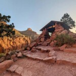
The highlight is definitely Shoshone Point at the end, a secluded and scenic overlook that’s one of the most beautiful places to visit in the South Rim. We visited early in the morning to catch the sunrise, and it was the most magical view I’ve ever seen. The overlook even has a picnic area with tables and a stone grill, and it’s the only spot in the park you can reserve for private events.
Unlike many other trails in the Grand Canyon South Rim, the Shoshone Point Trail is well-marked and maintained, with a gentle incline that makes it accessible for most hikers, including those in wheelchairs. Along the way, you might even spot local wildlife like deer, squirrels, and various bird species.
- Duration: 1 hour
- Distance: 2.1 miles
- Difficulty: Easy
- When to go: Year-round (but better during spring and fall)
- Route type: Out-and-back
- Obstacles: Slightly rocky
- Elevation change: 144 ft
8. New Hance Trail, the most challenging hike in the Grand Canyon South Rim
The New Hance Trail, also known as the Red Canyon Trail, is one of the most challenging and least maintained trails on the South Rim of the Grand Canyon, located within the primitive use area of the National Park. This hike is rugged and strenuous, with a 5,000-foot elevation change, rocky terrain, and no reliable water sources. So, it’s only a good fit for well-prepared and highly experienced hikers.

8. New Hance Trail, the most challenging hike in the Grand Canyon South Rim
Due to the trail’s difficulty and the time it takes to complete, the New Hance Trail is typically done as a multi-day hike rather than a single-day trek. You’ll find mid-canyon campsites both above and below the Redwall, all situated within the Red Canyon Use Area (BD9). And of course, you’ll need a backcountry permit to camp overnight. As I mentioned, the trail is located in the primitive zone, so you’ll need to be self-sufficient and bring all the necessary supplies, including food, water, and camping gear.
Part of the reason why the New Hance Trail is considered one of the toughest hikes in the Grand Canyon South Rim is the lack of amenities or marked pathways. You’ll have to navigate steep drops, loose rocks, and narrow ledges in a harsh environment. The good news is there’s only one way up and down, so you won’t get lost, but you’ll still need to use a map and GPS, and have strong navigation skills and a high level of fitness. It’s the perfect choice for those looking for a remote wilderness experience.
- Duration: 4-5 hours going down and 7-8 going up
- Distance: 11.7 miles
- Difficulty: Strenuous
- When to go: Spring and fall
- Route type: Out-and-back
- Obstacles: Scary rock slides, some scrambling, very little shade, and steep ascent
- Elevation change: 4,891 ft
Grand Canyon South Rim trails map
To help you navigate the region, I’ve included a map of the best hikes in the Grand Canyon South Rim below. You can also find the backcountry campsites I mentioned for overnight camping.
For more help, check out our guide with Grand Canyon South Rim maps, so you can plan shuttle rides, overlooks to see on your hike, and more.
How to get a backcountry permit (for overnight hikes at the Grand Canyon South Rim)
If you’re planning an overnight hike at the Grand Canyon South Rim, you’ll need a backcountry permit for camping outside the developed campgrounds. The only campgrounds in the South Rim where you can camp without a permit are Mather Campground and Desert View Campground.
Each backcountry permit covers a specific use area, date, and number of people. The overnight capacity of each area depends on its size, available campsites (whether designated or at-large), and ecological sensitivity. Some permits are easier to get, but popular spots like Bright Angel Campground (CBG) are in high demand. You can check out the full list of use areas here.

How to get a backcountry permit
To boost your chances of landing a permit in your desired spot, apply online for the early access lottery here. Make sure to do this during the two-week window ending on the 1st of the month, four months before your trip starts. For example, if you’re aiming for an October hike, apply by June 1st. The next day, 750 lucky winners will be notified and given a date and time to log into their Recreation.gov account to check availability and pay for their reservation. Any remaining spots will be available to other lottery applicants in the second half of the month, and to everyone else starting on the 1st of the following month (three months before your hike).

Backcountry permits for overnight hikes at the Grand Canyon South Rim
Permits cost $10 per application or permit, plus a nightly fee of $15 per person for areas below the rim and $4 per person for areas above the rim. The application fee is non-refundable, but the nightly fee is refundable for up to 30 days before the permit start date.
For more details on stay lengths, group sizes, and last-minute reservations (only for Havasupai Gardens), check out the information here.
Remember, you don’t need a backcountry permit for Phantom Ranch, but be aware that spots are allocated through this 15-month advance lottery due to high demand.
Additional tips for hiking in the Grand Canyon South Rim
Here are some pro tips to ensure you’ll enjoy the best hikes in the Grand Canyon to the fullest:
- Be prepared for the hot and dry conditions by wearing loose, light-colored clothing and sturdy hiking boots.
- Don’t forget sunglasses, a hat, and sunscreen.
- Carry plenty of water and snacks, as shade is scarce and some trails lack water stations.
- Download a map of Grand Canyon trails to your phone for offline use.
- Give mules the right of way on the trails.
- Start your hike early to enjoy cooler temperatures and daylight.
- Consider breaking up long hikes into multi-day trips for safety and enjoyment.

Additional tips for hiking in the Grand Canyon South Rim
- Let someone know your hiking plans and expected return time in case of emergencies.
- For out-and-back multi-day hikes, consider leaving hidden water caches along your route to lighten your load.
- Keep in mind that many water sources in the canyon are scarce, intermittent, and unreliable, and water must be purified before drinking. Here you can find the best ways to purify your water and stay hydrated on the trail.
- Check trail conditions and weather forecasts before you set out, especially if you’re visiting the Grand Canyon in winter as conditions can change very quickly. Park rangers can help inform you of the latest updates.
- Include a basic first aid kit with band-aids, antiseptic wipes, pain relievers, and any necessary personal medications in your Grand Canyon packing list.
- Plan your itinerary thoroughly, and make sure to factor in the Grand Canyon entrance fees and Grand Canyon operating hours.
- Lastly, keep in mind that some trails in the South Rim of the Grand Canyon are very challenging. For your first visit to the park, consider choosing shorter and easier trails located in the Corridor zone that suit your fitness and experience level.
FAQs – Best hikes in the Grand Canyon South Rim
Now that you know everything about the best hiking trails in the Grand Cayon South Rim, let’s address some of the most frequently asked questions:
And that wraps up our guide to the best hiking trails in the Grand Canyon South Rim! I hope you find this information useful for your next trip to the National Park. If you have any questions or want to share your own experiences, feel free to leave a comment below. I’d love to hear from you.
Safe travels!