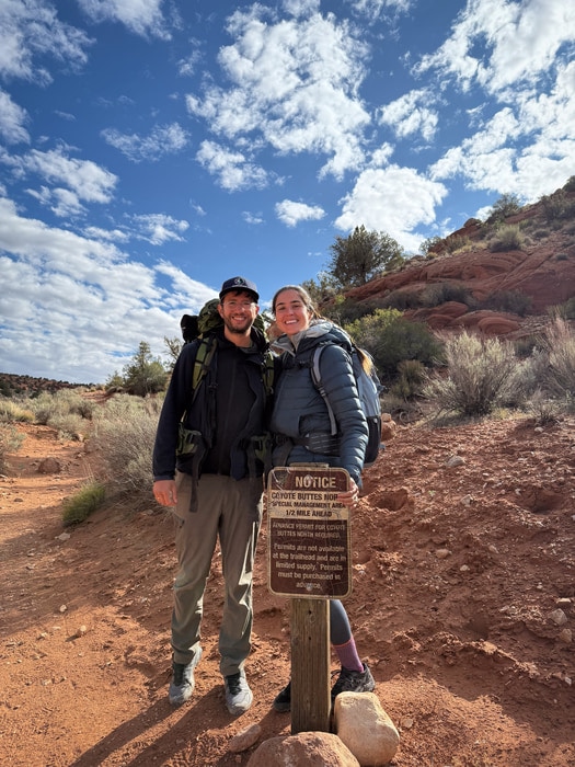
I don’t think anyone sees a photo of The Wave, Arizona, and doesn’t immediately dream of going there. I’m speaking from experience. I’ve been lucky enough to win the Wave lottery twice, and even now, with a commercial permit to run guided hikes in the area, it still feels surreal every time I step into that landscape.
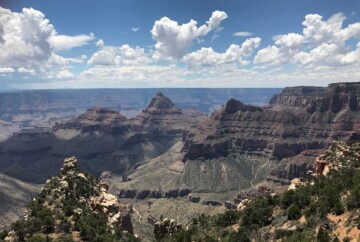
The first time I came across it, a few photos of the Wave popped up while I was researching places to photograph in the Southwest, and I was instantly captivated. I had already visited the nearby Grand Canyon North Rim and thought I knew Arizona’s landscapes, but this was something completely different.
The Wave sits in the heart of the Paria Canyon–Vermilion Cliffs Wilderness, an area that offers far more than just The Wave. Of course, there is no doubt that this iconic formation is the crown jewel. In this guide, I’ll share everything you need to know about visiting it, including how I won the lottery to hike the Wave twice!

The Wave, Coyote Buttes North, AZ | Permits, Photos + MAP
And if you’re one of the lucky ones who scores a permit and you want someone to show you around (and share a few hidden gems along the way), just reach out. I’d love to be your photography guide!
By the way: As a commercial guide, I have my own permit for Coyote Buttes North. That means I won’t count against the quota on your personal permit, so feel free to reach out!
Guide to visiting the Wave in Arizona
This is the most in-depth and practical guide to hiking The Wave, Arizona. Here’s what you’ll find inside:
-
- How to secure a Wave permit
- Tips for increasing your chances of winning the Wave lottery
- Hiking the Wave – Trail information
- Guided tours to the Wave, Coyote Butte North
- Top rock formations in Coyote Buttes North
- Best alternatives to The Wave
- My personal experience hiking the Wave
- Tips for visiting the Wave
- What to pack for the Wave hike
- Photography tips for The Wave
- Map of The Wave, Arizona, with major rock formations
How to secure a Wave permit: Tips from a two-time Wave lottery winner (and now an official Wave guide)
If you’ve heard the stories about how hard it is to get a permit for The Wave…well, they’re true. But don’t give up! I’ve won the Wave lottery twice before becoming an official Vermilion guide, and I’m here to share what actually works.
Each day, a maximum of 64 people or 16 groups are allowed into the Coyote Buttes North area, home of the legendary Wave formation. That number includes everyone in your group, even infants. (Dogs don’t count toward the limit, but they do require a $7 permit and must be included in your application.)

How to secure a Wave permit
There are two ways to get a permit, which I’ll explain in detail later:
- The Advanced Lottery
- The Daily Lottery
Here’s how the quota breaks down:
LOTTERY TYPE | # OF PEOPLE ALLOWED | GROUP LIMIT | HOW TO ENTER |
|---|---|---|---|
Advanced Lottery | 48 people/day | 12 groups | Online, 4 months ahead |
Daily Lottery | 16 people/day | 4 groups | Mobile only, 2 days before the hike |
HOW TO GET A WAVE PERMIT |
|||
Remember, the old walk-in lottery in Kanab was discontinued in 2022. If you’re serious about hiking The Wave, you need to understand how both lotteries work. So, let’s break them down.
Coyote Buttes North advanced lottery (The Wave)
If you’re planning your trip months in advance, the Advanced Lottery on Recreation.gov is your best option. You’ll need to apply during the calendar month four months before the month you want to hike.
I never won the Advanced Lottery myself, but here are a few important things to know before applying:
- You can apply only once per month, choosing up to three preferred dates.
- Applications open on the 1st and close at the end of the month.
- The lottery drawing happens on the 1st of the next month.
- If you win, you must confirm and pay by the 15th of that month.
For example: To hike any day in May, you apply in January; winners are notified on February 1st and should pay their reservation by February 15th.
You can list up to three alternate permit holders. These are people who can lead the hike if you’re not there. But be careful: anyone listed as an alternate can’t apply for their own permit that month, and vice versa. Each person can only be part of one application per month, either as the applicant or an alternate.
If you’re traveling with others, have multiple people in your group apply separately. Just don’t list each other as alternates unless you really need to.
The Wave daily lottery (Restricted by Geofence) — Walk-In Lottery Discontinued
Didn’t score an advanced permit for the Wave, Arizona? Don’t worry! You’ve still got a shot. The Daily Lottery is your best (and only) last-minute chance to hike The Wave.
Unlike the old walk-in process in Kanab, today’s daily permits are awarded digitally through a mobile-based, geofenced lottery. That means you can only enter the lottery if you’re physically located in a specific region near the Utah-Arizona border. And you must apply using your phone or GPS-enabled device; desktop computers won’t work.

The Wave daily lottery
To win this lottery, you must be located within one of the approved towns to apply. Turn on your GPS, and make sure your Recreation.gov app is working properly.
Geofenced towns include:
- Utah: Kanab, Big Water, Mount Carmel, Johnson Canyon, Glendale, Orderville, East Zion
- Arizona: Page, Fredonia, Marble Canyon, Vermilion Cliffs, Jacob Lake, Greenhaven, Kaibab Paiute Indian Reservation
Let’s break down the timing for applying for the Wave lottery:
- Day 1: Apply between 6:00 AM and 6:00 PM Utah time, two days before your hike. Results are emailed at 7:15 PM Utah time the same day. If you win the lottery, the window to accept your permit and submit payment opens immediately upon receiving the notification.
- Day 2: Winners must accept and pay by 8:00 AM Utah time, then attend an in-person orientation at 8:30 AM (Utah or Arizona time, depending on where you pick the permit). I’ll explain more about that orientation in just a bit.
- Day 3: Hike The Wave!
| Time Zone Note: Utah observes daylight saving time; Arizona does not (except for the Navajo Nation). From roughly March to early November, Utah is one hour ahead of Arizona. For example, in summer, when it’s 8:30 AM in Utah, it’s 7:30 AM in Arizona. The lottery system always runs on Utah time, but double-check which time zone your permit orientation is in, since you can attend from Kanab (Utah) or Page (Arizona). |
The Wave permit cost
Whether you win through the advanced lottery or the daily geofence lottery, both systems have the exact same fees. Here’s what you can expect to pay:
- $6 per group to enter the lottery – This is the non-refundable application fee you pay each time you apply, regardless of how many people are in your group. If you don’t win, this fee is still kept by Recreation.gov.
- $7 per person and per dog if you’re selected – This is the recreation fee, charged for every individual listed on your permit, including children, and for every dog you bring along. Dogs do not count toward the six-person group limit, but they still require a paid spot. The cost is the same whether you secure your permit months in advance or just two days before your hike.
These fees are set by the BLM to help protect and maintain this fragile desert landscape for future visitors. Keep in mind that all payments are final. If you cancel your trip, can’t make it, or weather forces you to change plans, no refunds are issued.
Tips for increasing your chances of winning the Wave lottery
Now for the big question: how do you actually win one of the most competitive hiking permits in the U.S.? I’d say the answer is a mix of persistence, strategy, and a bit of flexibility.
What are the odds?
The Wave lottery is known for low success rates, especially during peak seasons. Here’s a general idea of what to expect:
- Advanced lottery odds: Typically, 2–5% during peak seasons (March–May, September–November) and 5–10% during off-season months (December–February, June–August).
- Daily lottery odds: Often slightly better, around 5–10% during peak seasons and 10–20% in off-season months.
These numbers change depending on the time of year, day of the week, and weather conditions. For example, applying for a Monday in mid-July will almost always give you better odds than applying for a Saturday in April.
When to apply for better odds?
Some times of year are simply more popular than others. Spring and fall, with their ideal hiking weather, tend to be the most competitive.
When to apply for better odds?
To improve your chances:
- Apply for midweek dates instead of weekends
- Consider hot summer months (June to August), when demand drops due to extreme heat. Just be cautious; it gets dangerously hot.
I won one of my permits in late June. It was hot, but the trail was quiet and the landscape was just as stunning.
Applying as a group?
Group size matters in the lottery system. Since the quota is based on both people and groups, applying as a large group can work against you if your size doesn’t fit what’s left in the daily or monthly quota.
Here’s what to keep in mind:
- The lottery awards permits to groups, not individuals, so a group of six has lower odds than a solo hiker if only a few spots remain.
- The maximum group size is six, and the group must stay together for the entire hike.
- Everyone in your group must be included in the application; there are no last-minute add-ons.
- Infants count as group members; dogs do not, but they still require a permit and fee.
Can members of a group apply separately?
Yes, and this is one of the best ways to improve your odds, as long as you follow the rules. Ascen and I did exactly that. She was the one who won, and I joined as a group member both times.
Each person can submit one application per lottery period (monthly for the advanced lottery, daily for the geofence lottery). You may list up to three alternate permit holders, but anyone listed as an alternate cannot submit their own application that month.

Applying for The Wave lottery
To maximize your chances:
- Everyone in your group should apply separately with their own Recreation.gov account
- Do not list each other as alternates
- Coordinate ahead of time so you all apply for the same dates to increase your chances
Can you submit multiple entries?
No. Submitting multiple entries in the same lottery period is not allowed and will result in automatic cancellation of all entries. This includes:
- Submitting more than one application per person
- Being listed on more than one application (as either applicant or alternate)
Keep your application clean and honest. Recreation.gov strictly enforces the one-entry rule to keep things fair.
Best time of year to hike the Wave, Arizona
Let’s be honest: The best time to visit The Wave in Arizona is whenever you manage to get a permit. With only 64 people allowed in per day, it’s tough enough to win the lottery, so try not to get too fixated on chasing the “perfect season.” If your name is drawn, take it. Trust me, you may not get a better chance.

Best time of year to hike the Wave, Arizona
That said, seasons do change the experience.
- Spring (March–May): Mild weather, great light, high competition for permits.
- Summer (June–August): Fewer crowds and better lottery odds, but extreme heat (100°F+). Start at dawn and carry extra water.
- Fall (September–October): Similar to spring with mild temps and vibrant colors, but also high permit demand.
- Winter (November–February): Quiet trails, snow-dusted landscapes, and dramatic skies. Shorter days and possible icy patches; road may be impassable after storms.
| Pro tip: Your odds of winning improve in the hottest summer months and coldest winter weeks, but only attempt these if you’re prepared for the weather extremes. |
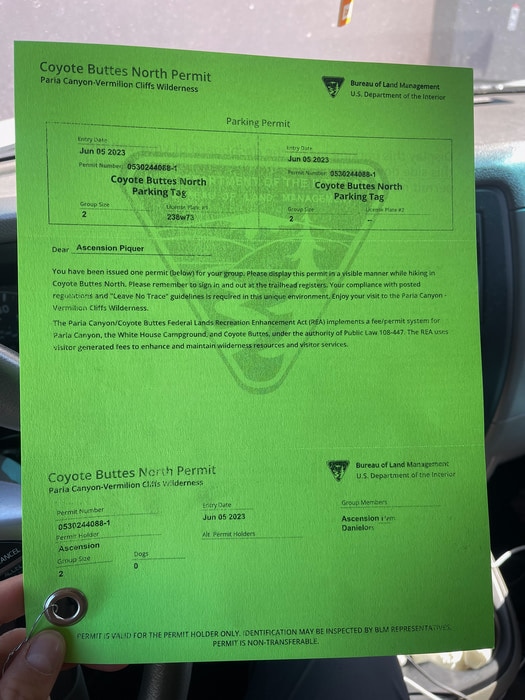
Permit pick-up and mandatory safety orientation for the Wave hike
Once you secure a permit, you’ll need to follow specific steps before your hike, including permit collection and, in some cases, a mandatory safety briefing.
For advanced lottery winners, your permit packet is emailed to you in advance. You’re not required to attend an in-person orientation, but it’s your responsibility to study the materials carefully before hitting the trail. These documents are your official tickets to The Wave, Arizona, so don’t leave them behind.
For daily lottery winners, the process is more hands-on. You’ll receive notification on the evening you apply (two days before your hike), and if selected, you must confirm acceptance and pay the fee the following morning by 8:00 AM Utah time. After that, you’ll attend a required safety orientation at 8:30 AM local time the day before your hike. You should select the town where you will attend the safety briefing when completing the payment after winning the lottery. See the Time Zone Note above to avoid confusion.
The Wave Permit
There are two official locations for orientation and permit pickup:
- Kanab Visitor Center (Kanab, Utah)
- Page–Lake Powell HUB (Page, Arizona)
Keep in mind that Utah follows daylight saving time, while Arizona does not, which can make timing a little confusing. For example, during summer, 8:30 AM in Utah is 7:30 AM in Arizona. Be sure to double-check which time zone you’re in and plan accordingly.
At orientation, you’ll receive:
- A physical permit for your group to carry on the hike
- A parking pass for your vehicle
- A detailed safety briefing, including GPS points and advice for navigating the route
This in-person session is mandatory. If you miss it—even by a few minutes—your permit will be forfeited, and you won’t be allowed to hike.
Whether you get your spot months in advance or just days before, all reservations for The Wave, Arizona, come with responsibilities. But I believe it’s all necessary to ensure that you’re fully prepared for one of the most remote and fragile landscapes in the Southwest.
How to get to the Wave Trailhead at Coyote Buttes North
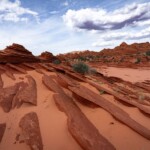
If you’ve secured a permit, the next big step is figuring out how to get to the trailhead. For those wondering about the location of The Wave, it sits in the heart of the Paria Canyon-Vermilion Cliffs Wilderness, right on the Utah–Arizona border.
The official trailhead for The Wave is Wire Pass Trailhead, which is also the starting point for Buckskin Gulch. This is the recommended and most clearly marked access to Coyote Buttes North. While there is a lesser-known route via The Notch, it’s no longer maintained or publicized by the BLM, and the trail is poorly defined. Unless you’re highly experienced in off-trail navigation, stick with Wire Pass.
How to get to the Wave Trailhead at Coyote Buttes North
Whether you’re coming from Utah or Arizona, all routes eventually funnel through House Rock Valley Road, a dirt road that can become impassable in winter or after rain. Always check the road and weather conditions before you head out.
- From Kanab, Utah: Head east on US-89, turn south onto House Rock Valley Road, then continue 8.5 miles until you reach the Wire Pass Trailhead parking lot.
- From Page, Arizona: Take US-89 NW, turn south on House Rock Valley Road, then continue 8.5 miles until you reach the Wire Pass Trailhead parking lot.
I highly recommend having a high-clearance vehicle, especially in muddy or washed-out conditions. While the roads are manageable in dry weather, they’re rarely maintained and can change dramatically after storms or even become impassable.
There is a small parking area and signage at Wire Pass, along with a vault toilet and the register box. Cell service is very limited or non-existent in this area, so it’s best to download maps and offline GPS tools before leaving town.
Hiking the Wave – Trail information
If you’re wondering how hard the hike to the Wave is, it’s as much about navigation as it is about endurance. It’s not especially steep or technical, but the challenge really lies in navigation and exposure. There are no signs, no shade, and you’ll need to rely on natural landmarks to find your way.

Hiking the Wave – Trail information
Here’s what you need to know before you start your journey from The Wave trailhead at Wire Pass:
- Distance: Approximately 4 miles round-trip (10.3 km)
- Time required: 3 to 5 hours
- Elevation change: Around 400–500 feet total gain, mostly gradual
- Difficulty: moderate in distance but challenging in navigation, exposure and terrain
- Navigation: You must follow GPS points and natural landmarks; getting lost is a real risk.
- Exposure: Full sun for the entire hike; no shade, no water sources, and intense heat in summer.
- Terrain: Soft sand and slickrock can slow your pace.
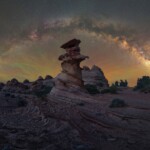
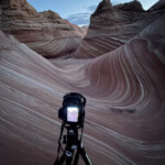
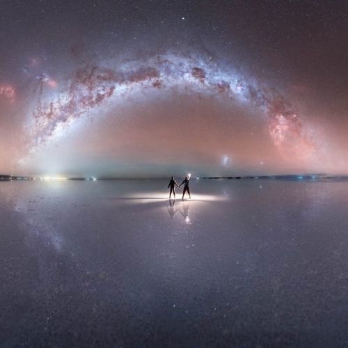
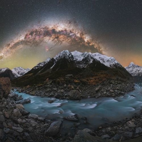
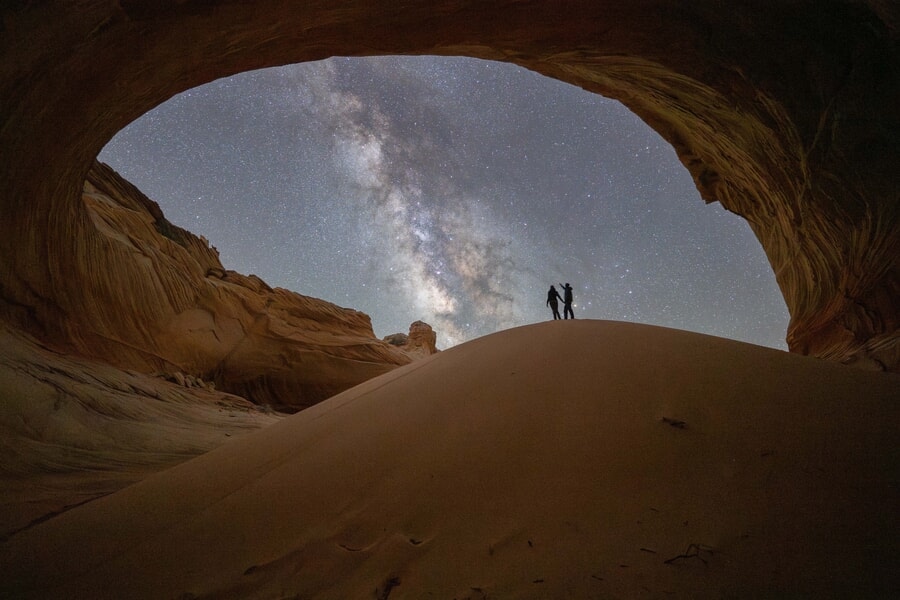
Starting from The Wave trailhead at Wire Pass, you’ll navigate through open desert, slickrock ridges, and sandy washes to reach one of the most iconic geological formations in the Southwest. I personally prefer to hike The Wave at night to avoid peak heat and photograph the Milky Way with this natural wonder as my foreground.
Thankfully, the permit is valid for 24 hours—from midnight to midnight—giving you plenty of time to explore, take photos, and truly enjoy the experience at your own pace.
Guided tours to the Wave, Coyote Butte North
As I mentioned, I offer guided photography and hiking tours to The Wave in Coyote Buttes North for those lucky enough to win a permit. The cost is $500 for 1–2 photographers, $800 for 3–4 photographers, or $1,000 for 5–6 photographers. We’ll meet at the Wire Pass Trailhead, and the tour will be fully customized to your interests — from exploring unique compositions and chasing the best light to, if the opportunity allows, staying up to 24 hours for Milky Way photography.
Guided tours to the Wave, Coyote Butte North
Please note that permits are not included; you’ll need to secure your own Coyote Buttes North permit before booking. Besides, I don’t accept last-minute bookings, so this service is only available for advanced permit holders. For the best chance of availability, contact me at least one month in advance. And don’t worry — as a commercial guide, I hold my own permit for Coyote Buttes North, which means I won’t count against the quota on your personal permit.
The most important thing to consider is that this is a moderately strenuous hike across varied terrain, so you should be well-prepared for the physical challenge. You’ll need to carry your own photography gear, water, snacks, and meals if you plan to spend the whole day in the area. Good footwear, sun protection, and being in good hiking shape are essential to fully enjoy the experience.
If you’ve secured your permit, I’ll help you capture The Wave like never before!
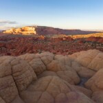
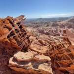
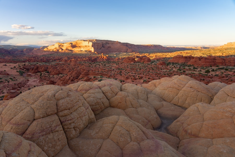
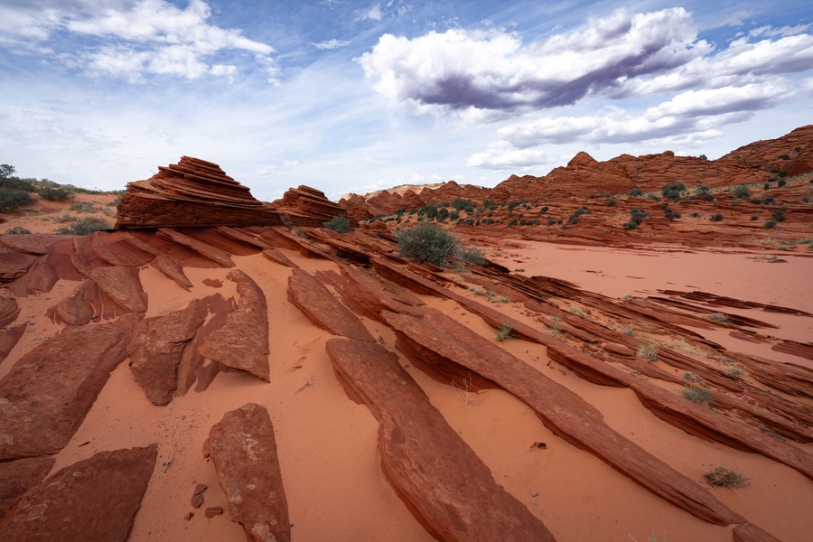
Top rock formations in Coyote Buttes North (Besides The Wave)
Don’t get me wrong. The Wave rock formation is stunning and totally worth the hype. But I absolutely love exploring beyond it. Here are some of my favorite formations from all my visits to The Wave. I loved each of these for different reasons, and they all had their own unique vibe:
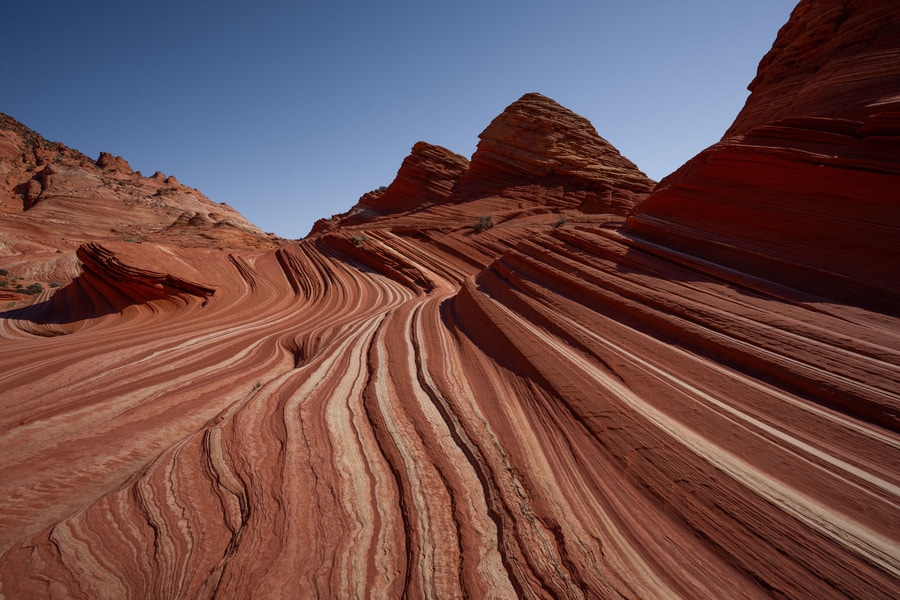
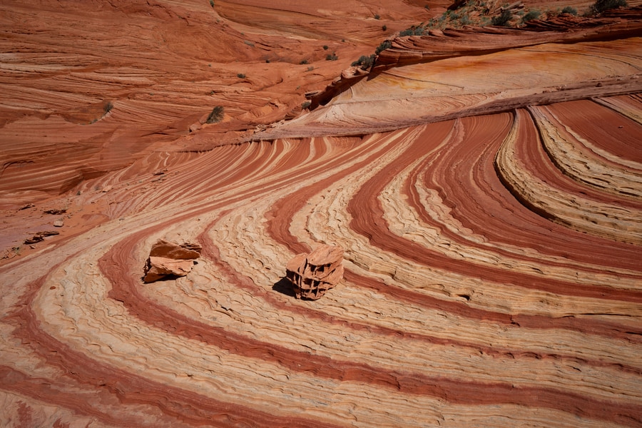
The Wave
Coordinates: 36.99595, -112.00629
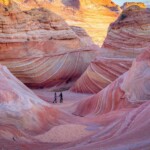
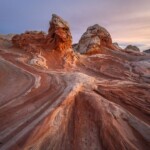
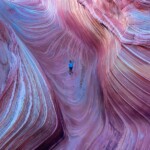
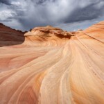
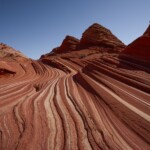
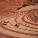
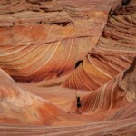
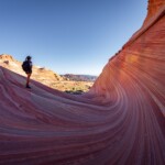
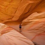
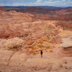
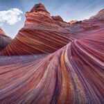
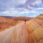
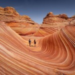
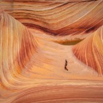
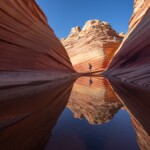
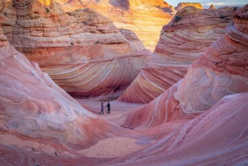
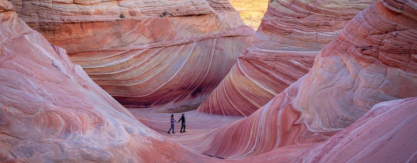
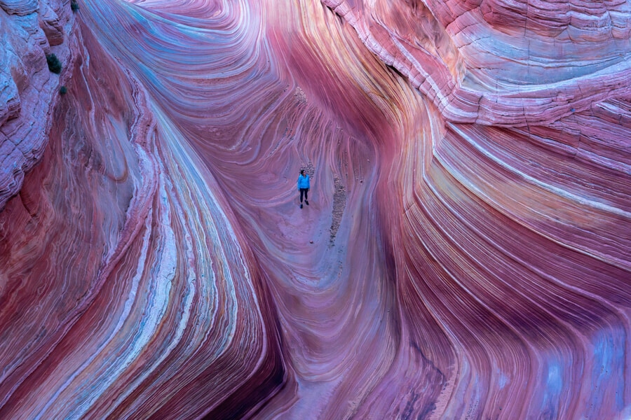
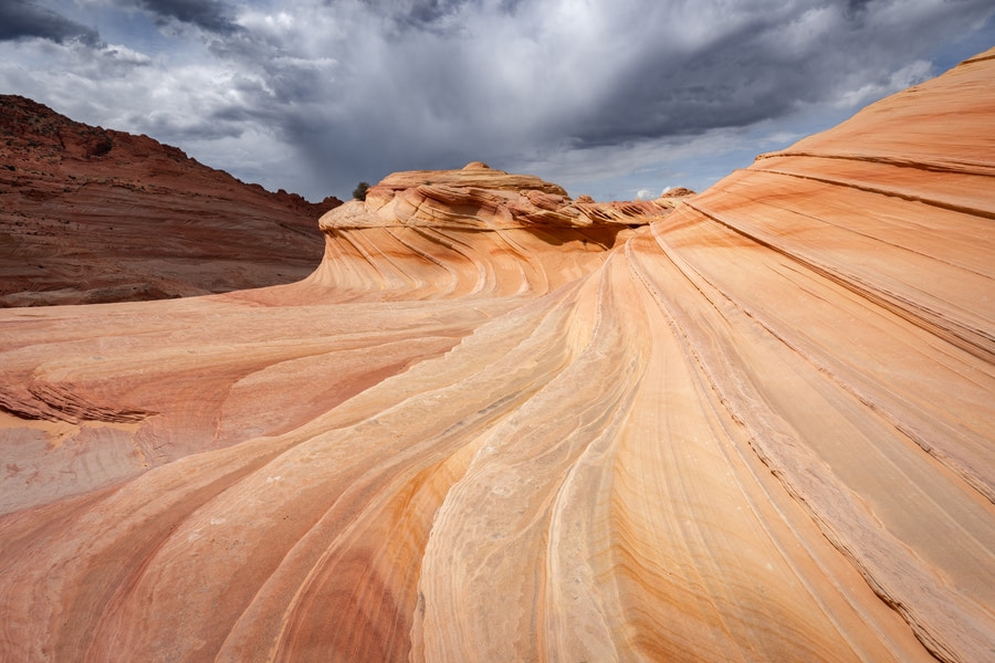
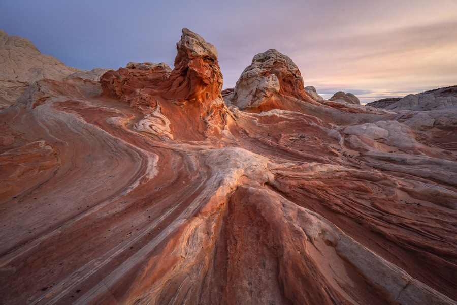
Nothing compares to standing before The Wave’s surreal, flowing curves and vibrant stripes. The two times I’ve visited on my own (not guiding groups), I used nearly the full 24-hour permit, determined to experience it in every kind of light. Each moment brought something unique, but my favorite was just before sunrise, when the silence and soft light made the entire scene feel otherworldly.

The Wave
This is the first formation you encounter upon reaching The Wave area, and if you’re lucky, heavy rains will leave behind a small pool that creates stunning reflections, especially magical during Milky Way season. From here, you can capture a variety of perspectives: the entrance facing south (where the pool usually is), the classic view facing west (the most popular views), the slot canyon looking east… but without a doubt, my favorite is from atop the butte to the west, where the sweeping view takes your breath away.
The Second Wave
Coordinates: 36.99344, -112.00812
This smaller formation lies just southwest of The Wave, and I stumbled upon it the first time by accident. It has gentler curves and a more muted color palette, but its calm atmosphere was what really drew me in. I remember sitting there in the afternoon, just watching the shadows slowly shift. Most people skip it, which makes it a peaceful spot to reflect and shoot photos without the pressure of crowds.
The Second Wave
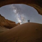
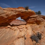
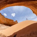
Top Rock Arch
Coordinates: 36.99366, -112.0051
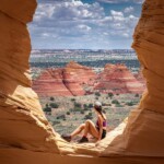
Top Rock Arch is one of those hidden rewards for hikers who like a bit of a climb. You reach it via the steep slickrock behind The Wave. It is tough, but worth every step. From up there, you can see the entire valley and get a different perspective on The Wave itself.
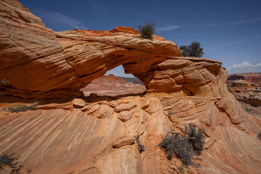
Top Rock Arch
The Alcove
Coordinates: 36.99201, -112.00577
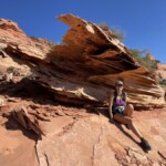
One of my favorite spots on the Top Rock plateau, The Alcove is like a natural amphitheater carved into the sandstone. Inside, a mini sand dune creates a dreamlike contrast to the yellow walls. The first time I visit, I climbed up from The Wave and wandered into it by following my GPS, and it felt like discovering a secret cave. The way the light filters in at midday, especially in summer, makes the colors pop in a way that photos can barely do justice.

The Alcove
Melody Arch and the Grotto
Coordinates: 36.99103, -112.00555
I usually visit Melody Arch on the same hike as The Alcove. Both are located in the Top Rock area. The little grotto here is so quiet and sheltered, it feels like stepping into a different realm. Soft beams of light cut through the openings and hit the sandstone just right. I love taking my time and trying to frame the arches with the North Teepees as the background. Here I have gotten some of my favorite photos of Coyote Buttes North.

Melody Arch and the Grotto
Hamburger Rock
Coordinates: 36.98954, -112.00195
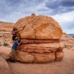
You can’t help but smile when you see Hamburger Rock. It really does look like a giant stone burger! You will pass it on your way to Top Rock from the eastern side, and the fun, stacked shape makes for some whimsical shots. The layered sandstone here is a bit chunkier than other formations.

Hamburger Rock
Hourglass Arch
Coordinates: 36.99074, -112.00864
Getting to Hourglass Arch is no joke. It’s perched in a more remote part of Top Rock and takes some scrambling. But the narrow, elegant shape is always worth the effort. I prefer to go there early in the morning, as the soft light makes its curves stand out perfectly. It’s not a spot many people get to, but that’s exactly what I love about it.
The Brain Rock Garden
Coordinates: 36.99638, -112.00559
This area is wild – clusters of bulbous, brain-like formations that look as if they were purposely sculpted. They are tucked away north of The Wave, toward the east. The shapes are compact and intricate, with natural grooves that give them such a curious appearance. Without a doubt, it’s one of my favorite spots to watch the sunset and see the last rays of light make the distant teepees glow. Every time I’ve come up here, I haven’t seen another soul, despite this place being only 5 minutes from the most popular spot in the entire Coyote Buttes North.
The Brain Rock Garden
Sand Cove
Coordinates: 36.99249, -112.0113
This wide, open area features swirling sandstone patterns, small domes, and scattered lace rocks. Best accessed via a sandy wash southwest of The Wave, Sand Cove shines in late afternoon light, especially in spring when winds settle. The swirls and layered textures are ideal for wide-angle landscape shots.
The Sand Cove
Rainbow Stone
Coordinates: 36.99315, -112.01020
I found Rainbow Stone while climbing a ridge near Sand Cove to get a better view of the area. The layered colors are jaw-dropping—like someone painted a rainbow right into the rock. I recommend going early or late in the day so the soft lighting brings out the best contrast.

Rainbow Stone
The Boneyard
Coordinates: 36.99552, -112.01308
This sprawling area of red and white ridged sandstone ledges is dotted with delicate lace rocks that resemble scattered bones, giving the place its name. The jagged contrast with the dark cliffs in the background creates a dramatic, almost prehistoric atmosphere.
The Boneyard
You can get there by heading west from the Sand Cove and navigating slickrock using GPS. The Boneyard is especially photogenic in late afternoon or at dawn in spring and fall, when shadows enhance the textures. These fragile rocks should be left undisturbed.
Lace Rock
Coordinates: 36.99692, -112.012473
Just above The Boneyard, there’s an area filled with fragile, lace-like boulders — hence the name Lace Rock. These airy sandstone formations have been sculpted by wind and water over time. I spent a lot of time here shooting close-ups; late afternoon light is best, as it really brings out the fine textures without the harsh shadows. It’s such a peaceful little corner of the area.

Lace Rock
Dinosaur Tracks
Coordinates: 36.99925, -112.00988
Embedded in slickrock about a half-mile north of The Boneyard, these fossilized dinosaur footprints offer a rare glimpse into prehistoric life. The tracks vary in size and are often easy to spot in mid-morning light, which provides even contrast without deep shadows. These photogenic impressions are well preserved and rich in paleontological interest.
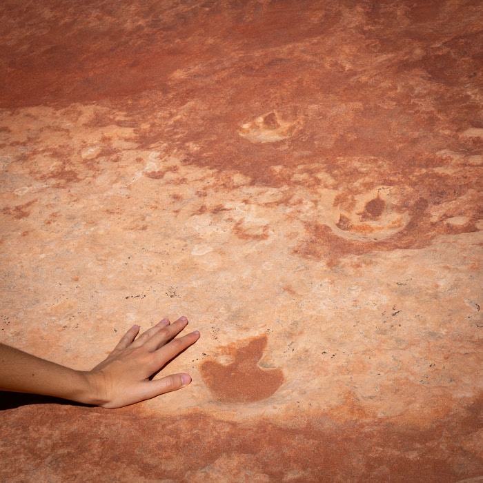
Dinosaur Tracks
Ginger Rock
Coordinates: 36.99745, -112.00548
A little northeast of The Wave, this modest formation might be named for its ginger-like color. I loved its smooth, undulating texture. It’s easy to pass by, but if you have a bit of time and good light, stop by. I find that even the strong midday sun works well here, making the rock’s curves and patterns pop clearly in photos.

Ginger Rock
The Fins
Coordinates: 37.00034, -112.00552
This striking group of vertical sandstone slabs rises like blades north of The Wave. Actually, it’s a stop you can do on your way to the Wave. Their tall, narrow forms are best photographed in late morning, when the sun’s angle highlights the textures and vertical striations. The unique structure stands out sharply against the surrounding landscape.
The Fins
Other rock formations most people don’t visit
One day is not enough to visit all the different rock features in Coyote Buttes North. Most people only focus on the Wave area, but there are many other places to explore. This place is massive, and every ridge seems to hide something new. I’ve made a list of formations that I recommend leaving for a second or third visit.

Other rock formations most people don’t visit
High Heel Arch
Coordinates: 37.01036, -112.01648
High Heel Arch, with its high-heeled shoe shape, is a striking formation that sits just west of the main trail, outside the Coyote Buttes North permit area. Part of the arch collapsed recently, giving it an even more dramatic look. It’s best seen in the late afternoon, when the soft light makes its curves glow.
To reach it, start your hike toward The Wave and, about halfway across the sage field, turn south. From there, it’s roughly half a mile to the arch. Access can be a bit tricky, with some scrambling involved, though you can also admire it from below if you prefer to skip the climb.
Dick’s Arch (Arc of the Wave)
Coordinates: 37.00038, -112.01676
Dick’s Arch is a striking natural span South of High Hell Arch. Measuring 54 feet across and 18 feet high, it’s surrounded by photogenic lace rocks and several smaller arches. The best light for photography hits the arch around midday.
Moby Dick Arch
Coordinates: 37.00736, -112.01728
South of High Heel Arch, there’s a little-known rock span shaped by a wash running directly beneath it, Moby Dick Arch. Measuring around 30 feet across, it’s an impressive find for those exploring beyond the main landmarks. While it’s not the area’s most dramatic feature, it can still deliver striking shots — especially if you position yourself for a sunrise sunburst in spring or summer. A wide-angle lens helps, though shooting a stitched panorama will capture its scale best. Sitting outside the Coyote Buttes North permit area, it’s an easy side trip to combine with other nearby arches.
The Notch Arch
Coordinates: 36.98891, -112.01818
Tucked away near the high pass known as The Notch, Notch Arch is a delicate sandstone opening spanning roughly ten feet. Its compact size is part of its charm, framed by the sweeping views of Coyote Buttes North. The most straightforward way to reach it is to hike up The Notch trail and, from the top, make a careful traverse about 0.15 miles to the north-northeast. The slope is loose underfoot and slightly exposed, so sure footing is important. Few visitors make the detour, but those who do often come early in the morning, when the low sun lights up the arch’s underside with a warm, golden glow.
Maze Petroglyphs
Coordinates: 36.98501, -112.02615
The Maze Petroglyphs sit just outside the Coyote Buttes North permit area, making them an easy and worthwhile stop from The Notch trailhead. Etched into a red sandstone wall on the right side of the canyon, the panel features intricate geometric shapes and symbolic patterns that offer a fascinating glimpse into the region’s past. Afternoon light is ideal for photography, enhancing the carvings’ detail and the warm tones of the rock.
Best alternatives to The Wave
If you don’t win tickets to The Wave Arizona, don’t worry! There are incredible alternatives nearby, many of which I’ve explored myself. Some are permit-free, others are much easier to access, and each offers a unique desert experience.
Coyote Buttes South
I’ve visited Coyote Buttes South multiple times since it’s another area where I run photography and guided hiking tours, and while it’s wilder and less visited than the North, the formations here are no less stunning. You’ll find sweeping fins, twisted hoodoos, and alien-looking landscapes like Cottonwood Cove and Paw Hole. The terrain is rougher, and it requires a permit, but not a lottery. All you need is a bit of planning and a 4×4 high-clearance vehicle.

Coyote Buttes South
White Pocket
White Pocket is one of my favorite places in the entire Vermilion Cliffs region. It’s like someone swirled red, orange, and white sandstone into a lava lamp and then hit “pause.”
White Pocket
You won’t need a permit to visit, but definitely a 4WD vehicle. Each time I go, it feels like I have the place to myself. No footprints, just wild domes, brain rocks, and swirling mushroom shapes. It’s raw, peaceful, and absolutely unforgettable.
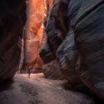
Wirepass Slot Canyon
This short but dramatic slot canyon shares a trailhead with The Wave, so it’s a great add-on while you’re in the area. It’s beginner-friendly and incredibly photogenic, with towering narrow walls, filtered light, and even a small petroglyph panel, if you look closely. You can reach it without a guide, and no permit is required unless you go beyond the confluence with Buckskin Gulch.
Buckskin Gulch
I’ve only done a short section, but even that was enough to leave me speechless. Buckskin Gulch is one of the longest and deepest slot canyons in the Southwest. Walking between those towering rock walls makes you feel tiny in the best way. I entered from the Wirepass trail and just did the stretch to the confluence. No camping; just a day permit ($6/person), but it was so worth it.

Buckskin Gulch
Paria Canyon
I haven’t done the full Paria Canyon backpacking trip yet. It’s still on my bucket list, but I’ve explored the lower section near Lees Ferry. The layered walls and rich colors are breathtaking. This is a serious hike, usually done over multiple days, which requires advance permits and detailed planning. It’s one of the region’s most iconic wilderness treks.
Edmaiers Secret
This spot feels like a hidden dreamscape. I found it while exploring beyond The Wave permit area and couldn’t believe the variety: brain rocks, hoodoos, and delicate crossbedding that stretches like fossilized waves. There’s no official trail, so GPS is essential, but it’s doable without a permit. Sunrise here lit the ridges in soft oranges that I’ll never forget.
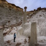
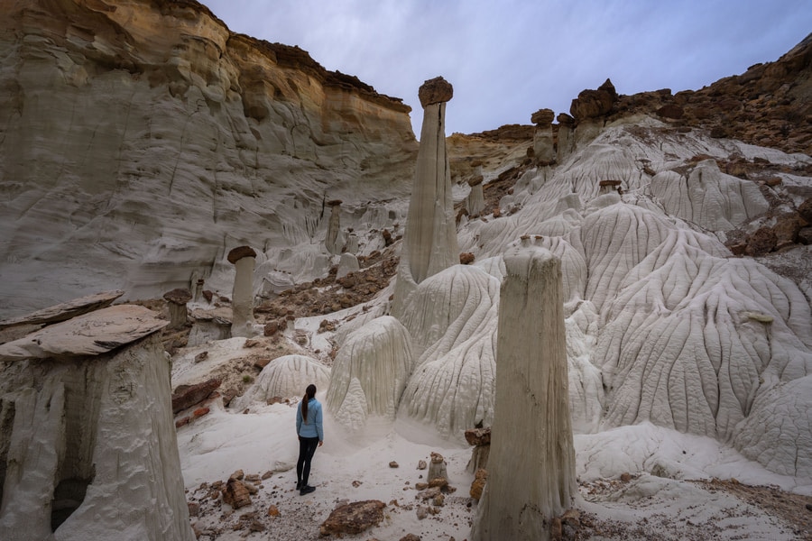
Toadstool Hoodoos
This one’s right off Highway 89, and I have visited hundreds of times. The trail is short and easy, making it perfect for a quick stop. The main hoodoo (a red cap balanced on a pale pedestal) makes for great photos, and the surrounding badlands have a lot of subtle beauty.
Toadstool Hoodoos
Sidestep Canyon and the Wahweap Hoodoos
The Wahweap Hoodoos are striking white pillars topped with dark boulders, unlike anything else in the region. The hike is long (about 9 miles round-trip), but manageable. Sidestep Canyon, nearby, is filled with sandstone fins and slickrock patterns similar to Edmaiers Secret.
Wahweap Hoodoos
The New Wave in Page
I’ve walked this short loop trail just outside of Page a couple of times. It’s a convenient and free option if you’re staying nearby. While it’s nowhere near as grand as the real Wave, some of the formations have a similar ripple pattern, and it’s a nice warm-up hike with great views of Lake Powell.
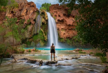
If you’re doing a tour of the Wave, Arizona, check out my guide on the top attractions near the Grand Canyon. There’s something in there for every hiker and landscape lover.
My personal experience hiking the Wave at Coyote Buttes North
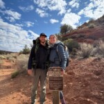
Before becoming an official Wave guide, I was lucky enough to hike to The Wave in Arizona twice (once in June 2023 and again in April 2025) and both trips were unforgettable for very different reasons. The first time, it was just Ascen and me. We had been applying for the old in-person lottery for years with no success—eight tries without a win. We did win a permit for Coyote Buttes South on our fourth attempt, which was an amazing consolation prize.
When the walk-in lottery system was replaced by the geofence daily lottery for The Wave AZ, we figured we had nothing to lose. So, we parked our campervan in Kanab, cleared a couple of weeks in our schedule, and waited. After 11 more attempts (19 total!), we finally won on our last possible day before flying to Peru. The full moon washed out any chance of Milky Way photos that night, but it didn’t matter. Walking into that surreal landscape for the first time was magical. Every curve of sandstone, every ripple of color felt like entering a place that shouldn’t exist on Earth.

My personal experience hiking the Wave at Coyote Buttes North
In April 2025, we got to share the experience with friends. Two close friends from Spain were visiting and planned to be in the area for a few days. We all applied through the geofence system, not expecting much, especially with a larger group. But to our shock, we won on the fourth try. This second hike to The Wave was even better in some ways. The spring weather was perfect, the lighting was incredible, and I finally got to do night photography that I’d dreamed of for years.
After that trip, I knew I wanted to help others experience the magic of The Wave for themselves. We applied for a commercial permit, and thanks to our long history of working with the BLM and National Park Service across the U.S., our application was approved. Today, we can officially guide others into this extraordinary landscape, sharing not just the route and logistics, but also the photography tips, local knowledge, and sense of wonder that make The Wave such a once-in-a-lifetime adventure.
I know how disappointing it is to miss out on the lottery multiple times. For us, the lottery for The Wave, AZ, was a real exercise in patience. Nineteen tries over multiple years sounds like a lot – and it is – but it made the hikes all the more special. If you’re on the fence about whether to keep applying, my advice is: keep going. It’s absolutely worth the wait, and I hope I can be the one to help you finally step into this incredible place, guiding you through its hidden corners and helping you capture it in a way you’ll never forget.
Tips for visiting the Wave
As fun and exciting as visiting The Wave at Coyote Buttes is, there are a few important rules and details you really need to stay on top of:
- Be mindful of time zones. Page, Kanab, and Las Vegas are often in different time zones, especially during daylight saving changes. Be mindful of the Utah–Arizona time difference (see Time Zone Note). We once missed a lottery entry window because we misjudged the time.
- Manage your water wisely. We always bring more than enough water and hide extra bottles along the way in shaded spots, marking them on our GPS. It helps lighten your load for the return and adds a safety buffer in case something goes wrong.
- Use offline hiking maps. I highly recommend downloading the maps before you go. Use the map below that I’ve created in Maps.me. It has the trail to The Wave and most nearby rock formations clearly pinned.
- Plan for a full-day adventure. We spent nearly 24 hours inside the permit area both times we went by ourselves, even staying through the night to do astrophotography (one trip had a full moon, so no Milky Way that time).

Tips for visiting the Wave
- Don’t attempt to sneak in. On our second visit, we saw someone trying to sneak in after sunset without any water or warm clothing. He stayed less than 30 minutes and left visibly stressed. Not only is it illegal, but it also ruins the experience. Definitely not worth the risk.
- The hike is strenuous. It’s not technically difficult, but it’s long, hot, and completely exposed. The trail isn’t marked, so you’ll need strong navigation skills. But if you’re physically prepared, you’ll definitely find a lot to enjoy.
- Pack real meals. If you’re planning to spend 24 hours, bring a Jetboil and freeze-dried meals so you can enjoy a warm breakfast, lunch, and dinner while out there. It makes a huge difference when you’re out for 12+ hours in the sun.
- Pack up everything, including your waste. There are no restrooms on the trail or at The Wave. Bring WAG bags or a similar solution and respect the fragile desert environment.
- Bring a headlamp and warm clothes. Even if you don’t plan to stay late, it’s best to be prepared. Temperatures drop fast after sunset, and slickrock can be tricky in the dark.
- Expect ranger or volunteer checks. Both times we hiked, volunteers checked permits on the trail and at the Wire Pass trailhead. Make sure your parking permit is visible in your vehicle.
- Stick to the main trailhead unless you’re confident in navigation. We’ve always hiked from the Wire Pass trailhead, which is the standard route. Next time I’m not guiding a group, I plan to hike from The Notch, but it’s less defined and only recommended for those with solid backcountry experience.
What to pack for the Wave hike
Packing for The Wave is honestly part of the fun for me, and it always make a big difference during those long hours on the trail. Here’s what I recommend you bring:
- Printed permit. Don’t forget this! Digital copies won’t be accepted.
- Topographical map and GPS. Phone with Maps.me and the Vermilion Cliffs area will also work.
- Plenty of water (at least 1 gallon/person) or more. Use water caches.
- High-energy snacks
- Sunhat or buff
- Lightweight long-sleeve shirt
- Quick-dry hiking pants
- Sturdy trail running shoes or hiking boots
- Extra socks
- Fully charged phone + portable battery
- Sunscreen
- UV-blocking sunglasses
- Emergency blanket
- Electrolytes or sports drinks
- High SPF lip balm
- Headlamp
- First-aid kit
- Trash bags (leave no trace)
- WAG bags
- Lightweight tripod (for night shots)
- Trekking poles with rubber tips (optional, but helpful)
If you plan to stay all day, bring a Jetboil and freeze-dried meals.
Photography tips for The Wave, Arizona
Photographing The Wave, AZ, had been on my bucket list forever, and it totally lived up to the hype. Here are the tips that helped me make the most of my shots:
- Best light for photographing The Wave:
➜ Midday (10 AM–2 PM): Most even lighting across the main bowl, vivid colors, minimal shadows; the classic postcard shot. Also the busiest time.
➜ Early morning: Soft, golden tones and fewer visitors. Some parts may be shaded, which can add mood but reduce vibrancy.
➜ Late afternoon: Warm light and long shadows for dramatic compositions, but some areas fall into shade earlier.
➜ Before sunrise & after sunset: Gentle, pastel light and peaceful atmosphere. My personal favorite for a quieter experience, though not as popular.
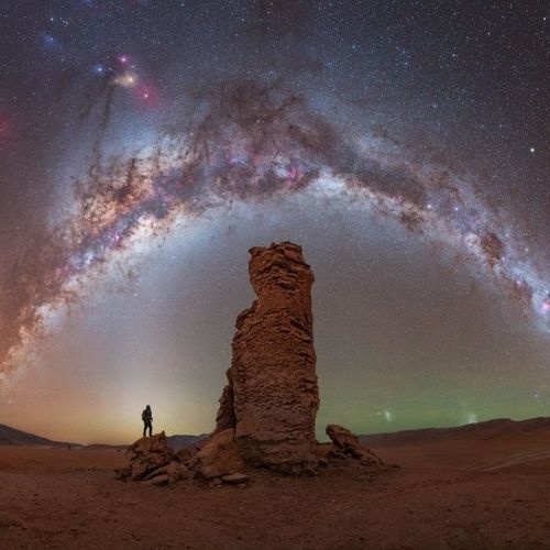
➜ Night: Milky Way season runs roughly from late March to early October. Download our Milky Way Calendar so you can apply for the advanced lottery on the best days.

Photography tips for The Wave, Arizona
- Bring the right gear: A wide-angle lens captures the sweeping rock formations, while a zoom lens is great for distant arches and textures. Don’t forget a sturdy light tripod for long exposures.
- Night photography essentials: Pack a headlamp with red light mode, extra batteries (especially in colder months), and warm clothes. Expect the temperature to drop quickly after sunset.
- Include human scale: Adding a person in your frame helps convey the massive size of some of the formations. Just make sure not to climb on delicate rocks.
- Keep lenses clean: The area is dusty. Bring microfiber cloths and air blowers to clean your gear regularly.
- Slow down and explore: The best compositions come from taking your time. Wander, crouch, and look at features from different angles. You’ll find shots that others miss.
- Respect the space: Avoid moving or climbing fragile formations just for a photo. This landscape is as delicate as it is photogenic.
Map of The Wave, Arizona, with all major rock formations in Coyote Buttes North
Here’s a detailed map of The Wave, AZ, and all the major rock formations in Coyote Buttes North that you absolutely shouldn’t miss. Be sure to download it on your phone in advance, as cell service out there is unreliable at best.
A bit of history before you go: How was The Wave created?
Before you stand in awe inside The Wave, it’s worth knowing just how incredible its backstory is. This breathtaking formation in Coyote Buttes North, within the Paria Canyon–Vermilion Cliffs Wilderness, was more than 190 million years in the making!
Back in the Jurassic period, this part of the Southwest was covered by a massive desert. Over time, those dunes were buried and compacted into what’s now known as Navajo Sandstone. With the help of pressure, minerals, and water, the soft sand transformed into solid rock through a process called lithification.

How was The Wave created?
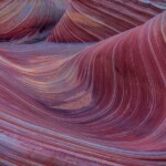
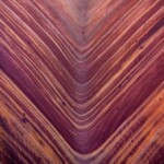
Then came the real artistry: millions of years of erosion. Wind and rain slowly carved away the layers of sandstone. Softer parts wore down faster, while harder layers resisted, forming the signature ridges, curves, and ripple-like waves you see today. The vivid red, orange, and yellow tones come from iron oxide and other minerals that stained the stone from within.
One of the coolest geological features you’ll notice is cross-bedding: those tilted, crisscrossing lines in the rock. These are ancient wind patterns frozen in time, showing how the direction of the sand dunes shifted as winds changed.
Despite its age, The Wave stayed off most people’s radar until the 1990s, when it popped up in photography books and computer wallpapers. Since then, it’s become one of the most sought-after hiking destinations in the U.S. When you finally stand inside, remember—you’re not just looking at a cool rock, but walking through nearly 200 million years of natural art carved by Earth’s forces.
FAQs – The Wave, Coyote Buttes North
We’ve now covered just about everything you need to know about The Wave in Coyote Buttes North. So, let’s finish with the answers to the most frequently asked questions:
That’s everything I can share about visiting The Wave, Arizona! I hope I’ve managed to pass along even a fraction of the awe and excitement this place always gives me. Photos barely scratch the surface; it’s a landscape you truly have to see in person.
If you’re one of the lucky few to win a permit and want to make the most of your day, I’d love to guide you there. From navigating the route to finding the best light and compositions, I can help you experience The Wave in a way that’s both unforgettable and stress-free. Get in touch to reserve your guided tour, and let’s make your Wave adventure extraordinary!