If you go to the beautiful Isla de Lobos, one of the most beautiful Canary Islands, Spain, and take advantage of your stay in Fuerteventura, you will need to plan your visit in advance. And what better tool for that than a good tourist map of Lobos Island?
If you don’t already know, in order to protect this natural area, the number of daily visitors is limited, as well as the time you have to explore the island.
You will need to request a special permit to disembark on Islote de Lobos. This permit will allow you to visit the island during one of the two four-hour shifts that run every day. That’s not very much time, is it?
To help you plan your visit so you don’t miss a thing, I have compiled the best maps of Lobos Island. Thanks to them, you’ll be able to find the essential places to visit on Lobos Island in a flash.
You can print out or take the map of Lobos Island with you on your smartphone. Do whatever’s best for you, since we’re giving you all the options.
Specifically, in this article you will find the following 8 maps of Isla de Lobos:
- Tourist map of Lobos Island
- Interactive map of Lobos Island
- Map of the Isla de Lobos main attractions
- Hiking trail map of Lobos Island
- Physical map of Lobos Island
- Map of Isla de Lobos and Fuerteventura
- Map of Lobos Island and the Canary Islands
- Isla de Lobos map for downloading
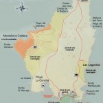
Tourist map of Lobos Island (Fuerteventura)
With the following tourist map of Lobos Island, you can get an idea of where the main attractions are.
")
Interactive map of Lobos Island (Canary Islands)
The interactive map of Lobos Island that we have created has all the essential places to visit. Are we missing anything? Feel free to leave a comment telling me what other places you would like me to add to the map and I will be happy to do so.
In addition, at the end of this post, I’ve left you the link to download this map of Isla de Lobos so you can use it offline.
Map of the Lobos Island main attractions
I hope this map of the Lobos Island main attractions will help you during your visit to the island. Although time is limited, it is totally feasible to see them all in the four hours that the permit lasts, since, fortunately, the island is not too large.

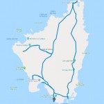
Hiking trail map of Lobos Island
With this Lobos Island hiking trail map, I want to share the best way to explore the island. With this circular route, which I recommend doing by bicycle, you can see everything within the allotted time.
The start and endpoint of the route, which is where you travel to and from Fuerteventura, is marked with a red pin on the south of the island.

Hiking trail map of Lobos Island
If you prefer to walk, it’s also a great option, but give yourself enough time. Anyway, you won’t regret it. It’s one of the best hikes in Fuerteventura.
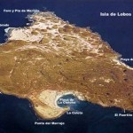
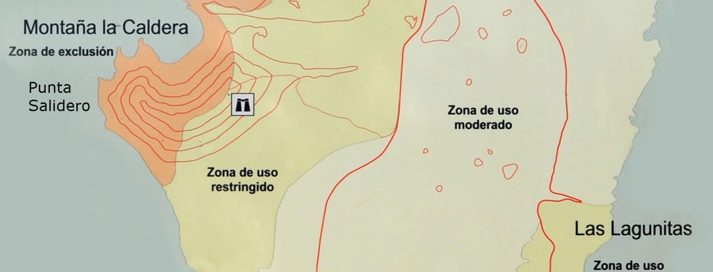
Physical map of Lobos Island
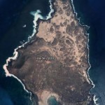
As you can see on the following physical map of Lobos Island, the island’s topography is of volcanic origin, just like all the other Canary Islands.
One of the most interesting things to do on this island is climbing the large caldera that can be seen on the west of Isla de Lobos. On the physical map, it is clearly visible as the old caldera of an already extinct volcano.

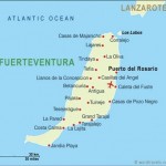
Map of Lobos Island and Fuerteventura
On the following map of Fuerteventura and Isla de Lobos, you can get an idea of the small size of Lobos Island compared to Fuerteventura.
The Islote de Lobos is close to Corralejo, in Fuerteventura, and is located between Fuerteventura and Lanzarote.

Map of Lobos Island and Fuerteventura
As seen on this map of Isla de Lobos, the best way to get there is by taking a boat from the port of Corralejo.
Map of Lobos Island and the Canary Islands
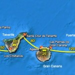
Although on the following map of Lobos Island and the rest of the Canary Islands, you can hardly see the tiny Islote de Lobos, it might be useful for seeing the various routes you can take to get to this island.

Canary Islands map
The only way to visit Lobos Island is by boat from Fuerteventura. On the following map, you can see the connections from one island to another by ferry, but remember that you can also take a flight to get to Fuerteventura.
Lobos Island map for downloading
Finally, here is a Lobos Island map for downloading so you can have it on your smartphone to use offline and check it at any time.

To use it, install the Maps.me app on your phone and look for “Isla de Lobos.” The app will then download all the information about the island. Then, save the map you have downloaded on our website in the Dropbox app and open it on your phone using the Maps.me app. That way, all the places of interest are added and you can check them at any time.
With these maps of Lobos Island, you are ready to explore the island and enjoy its beauty.