When traveling abroad, get a policy from one of the best travel insurance companies. Get a 5% discount on Heymondo, the only insurance that pays all medical bills upfront for you, HERE!
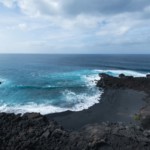
This particular Canary Island may be known for its beautiful beaches, but there are many hikes in Lanzarote that are worth doing. While exploring these walking trails, you can see some of the most popular places in Lanzarote and spectacular volcanic landscapes.
One of the best ways to see the turquoise waters and the ochres, reds, and browns of the mountains and volcanoes is to go hiking in Lanzarote. There are easy, kid-friendly routes and longer, more challenging trails for seasoned hikers. Whichever route you take, I guarantee you’ll fall in love with the magnificent views along the way.
To help you find the perfect trail for your visit, I’m sharing the 10 best hikes in Lanzarote. At the end of this guide, you’ll find a Lanzarote trail map with all the hiking routes, as well as some tips for your adventure.
1. Pico Redondo – Los Ajaches, the best hike in Lanzarote
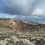
Pico Redondo is one of the most famous hikes in Lanzarote, so you can’t miss it. It’s part of Los Ajaches Natural Monument, an impressive volcanic formation that covers nearly the entire southern part of the island.
This area is around 15 million years old, and the path surrounding it varies in terrain. Back in the day, this Lanzarote walking route was used by shepherds who would guide their herds of goats. These days, this Lanzarote hike is dog-friendly, but you must keep your pup on a leash.

1. Pico Redondo – Los Ajaches, the best hike in Lanzarote
Begin the hike in the town square of Femés, a small village. After a short ascent, you’ll see a panorama of the Barranco de la Higuera and part of El Pozo Beach.
The next part of this Lanzarote hike continues downward towards Pico de la Aceituna and Degollada de Carlos, where you’ll see Playa Blanca and Fuerteventura in the distance. If it’s a clear day, look behind you to see Puerto del Carmen further out.
The route continues to the bottom of the Barranco de la Casita before ascending through the Refugio del Aljibe, where you’ll notice there is still a watering hole for goats. During the final leg of the route, you’ll go through the Morro de la Lama del Pozo, where you’ll cross the Barranco de la Higuera again and ascend to the trail’s end.
- Distance: 4.3 miles
- Duration: 5 hours
- Difficulty: Moderate
- Type: Loop
- Elevation gain: 2,086 ft
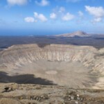
2. Caldera Blanca, the best hike in Lanzarote for kids
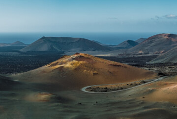
The Caldera Blanca is a trail in Lanzarote that leads to a volcanic crater about 3,940 feet in diameter, one of the most popular volcanoes in Lanzarote. It was formed after one of the great eruptions that occurred between 1730 and 1736. In addition to this magnificent sight, you’ll also be able to appreciate some breathtaking landscapes along the way.
If you want to challenge yourself a bit with a Lanzarote volcano hike, this route is a great choice. It’s suitable for all levels, and it’s a popular hike to do with kids.

2. Caldera Blanca, the best hike in Lanzarote for kids
To start, you’ll have to go to the town of Mancha Blanca and follow the road to Timanfaya National Park until you see a detour to Caldera Blanca. The trailhead is about 1.9 miles from the Visitor Center and is marked with a sign, so you shouldn’t have any problems finding it.
From there, follow the 6.2-mile route directly to the volcanic crater. It’s at an elevation of about 1,500 feet, so it’s a moderate Lanzarote hike. Moreover, the volcano is part of Los Volcanes Natural Park, which borders Timanfaya National Park, one of the best national parks in Spain.
Keep in mind that just before you get to the caldera, you’ll be able to see La Caldereta, a smaller volcano. I recommend capturing some photos of the unique landscape and colors before making the return trip back to the start.
- Distance: 6.2 miles
- Duration: 3-4 hours
- Difficulty: Moderate
- Type: Loop
- Elevation gain: 1,417 ft
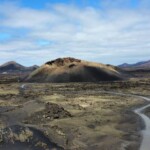
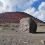
3. Caldera Colorada, a family-friendly hike in Lanzarote
Here is another beautiful hike in Lanzarote, this one leading to the Caldera Colorada, an imposing volcano in spectacular shades of red. The best part of this route is that it’s mostly flat, so it’s a good choice if you’re traveling with kids, older family members, or you just want an easy hike.

3. Caldera Colorada, a family-friendly hike in Lanzarote
This Lanzarote walking route is well-marked and starts from a parking lot on road LZ-56, at the base of the volcano. Throughout the hike, you’ll get lovely views of the volcano and the surroundings, including lava flows and all kinds of colorful landscapes.
The highlight of this hike is that you’ll see the largest lava bomb in the world, which was ejected from the volcano over 300 years ago. Without a doubt, it’s one of the coolest things to see during your visit to Timanfaya National Park.
- Distance: 1.9 miles
- Duration: 1.5 hours
- Difficulty: Easy
- Type: Loop
- Elevation gain: 72 ft
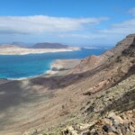
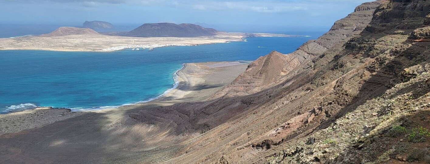
4. Camino de los Gracioseros, a hike in Lanzarote with views of La Graciosa
The Camino de los Gracioseros is a historic hiking trail in Lanzarote that was formerly used by the inhabitants of the nearby island of La Graciosa. Considered one of the best Canary Islands, La Graciosa is just a few miles north of Lanzarote.
As you make your way along this Lanzarote hiking route, follow a volcanic rock path across the Famara cliffs to Playa del Risco, getting incredible views of La Graciosa and the Chinijo Archipelago along the way.

4. Camino de los Gracioseros, a hike in Lanzarote with views of La Graciosa
To get to the trailhead, you must take the detour to the Mirador del Río, an architectural wonder built by the famous Canarian artist César Manrique. Just before entering the town of Yé, follow the narrow path that winds down the Famara cliffs.
The last part of this Lanzarote hike takes you to the wild and rustic Playa del Risco, which is known for its fine white sand. Reward yourself for your efforts by taking a dip in the refreshing turquoise waters. Also, the Salinas del Río salt flats are nearby, so be sure to check them out. Dating back to the 15th century, these salt flats are the oldest in the Canary Islands and are home to several unique species that have survived the hostile terrain.
- Distance: 3.1 miles
- Duration: 3.5 hours
- Difficulty: Moderate
- Type: Out & Back
- Elevation gain: 1,404 ft
5. Tremesana Route from Yaiza, the best volcano hike in Lanzarote
The Tremesana Route is a Lanzarote hiking trail that goes through Timanfaya National Park. You can only do this route with an official guide, so if you’re interested, you must make a reservation on the park’s website. Spots are limited per day, so I recommend reserving well in advance (it’s free and one of the best things to do in Yaiza).

5. Tremesana Route from Yaiza, the best volcano hike in Lanzarote
While you have to reserve a spot, this hike in Lanzarote is free to do. It begins at the Mancha Blanca Visitor Center, where you’ll board a van that will take you to the trailhead. The trail itself is in very good condition, so it’s a great Lanzarote hike to do with kids.
During the hike, you’ll see colorful lava fields and volcanoes while your guide tells you about the different eruptions that hit the island and how the locals had to adapt. For example, they need to use different cultivation methods in their vineyards to produce wine. All in all, this is a great hike you can do in a few hours while learning more about the local culture and geological history.
- Distance: 1.9 miles
- Duration: 3 hours
- Difficulty: Easy
- Type: Loop
- Elevation gain: 1,391 ft
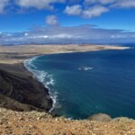
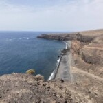
6. Coastal route from El Golfo, a Lanzarote hike by the sea
The Ruta del Litoral is a coastal hike in Lanzarote that runs through Timanfaya National Park. You can do this hike without a guide, but if you want a park ranger to lead you along the path and point out all the sights, you must reserve a free spot here.

6. Coastal route from El Golfo, a Lanzarote hike by the sea
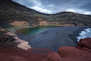
The route begins in the town of El Golfo, a small fishing village close to one of the best beaches in Lanzarote, Charco de los Clicos, a black sand beach. There is a parking lot here where you can leave your car, so I recommend spending the day exploring this area before or after doing the hike.
As for the trail, it’s well-marked and goes past a variety of volcanic terrain, which contrasts with the turquoise waters and steep cliffs. At the end of this Lanzarote hike, you’ll see Playa del Paso, a black sand beach with strong, crashing waves. Here, you can catch one of the most impressive sunsets in Lanzarote, so I recommend planning your hike, so you get here before dusk.
- Distance: 4.3 miles
- Duration: 3 hours
- Difficulty: Easy
- Type: Out & Back
- Elevation gain: 213 ft
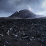
7. Volcán de la Corona, one of the most popular hikes in Lanzarote
The Volcán de la Corona route is one of the most famous hikes in Lanzarote. This 3,000-year-old volcano had such a strong eruption that it spewed lava across seven square miles, forming the Malpaís de la Corona.
The start of the trail is in the town of Yé, in the church parking lot. To the right, you’ll see the trailhead, which winds through vines, fig trees, and prickly pear trees before ascending to the crater. The slope has an elevation gain of about 1,100 feet, so it’s quite challenging. Even so, you’ll be rewarded with spectacular views and an impressive crater about 1,476 feet in diameter.

7. Volcán de la Corona, one of the most popular hikes in Lanzarote
If you have enough energy after the climb, you can continue this Lanzarote hike down to the bottom. I recommend doing so since the views are completely different and worth seeing. To return to Yé, follow the same path.
Due to its steep ascent and the narrowness of the path towards the end, this is a moderate trail in Lanzarote, but it’s very enjoyable.
- Distance: 3.7 miles
- Duration: 3 hours
- Difficulty: Moderate
- Type: Loop
- Elevation gain: 1,099 ft
8. Cuervo Volcano route, another unique hike in Lanzarote, Canary Islands
The Cuervo Volcano route is a simple hike in Lanzarote, and it’s part of some of the most popular Lanzarote volcano tours. I chose to do this excursion since it also includes the Caldera Colorado route that I mentioned earlier.
While we don’t mind hiking on our own, we wanted to learn more about the history of these fantastic volcanic landscapes, and our guide, Pedro, did an amazing job. I’m glad I booked this tour, as I could concentrate on enjoying the hike while discovering more about these beautiful surroundings.

8. Cuervo Volcano route, another unique hike in Lanzarote, Canary Islands
That said, if you prefer to do this Lanzarote hike on your own, the trailhead is at the parking lot on road LZ-56, about 1.5 miles from Masdache and two miles from Mancha Blanca. Look for the sign indicating the entrance to the municipality of Tinajo, and you’ll find the path right next to it.
As for the route, it’s flat and well-worn, so it’s one of the best hikes in Lanzarote to do with kids or family. Once you reach the crater, you can see different volcanic formations, views of La Geria, and all kinds of colors in the landscape.
To return to the start, circle back along the same path, skirting around the volcano to the parking lot. Again, you can combine this route with the trail to Montaña Colorada.
- Distance: 3.1 miles
- Duration: 5 hours
- Difficulty: Moderate
- Type: Loop
- Elevation gain: 75 ft
9. Montaña Roja, another Lanzarote hike with amazing views
Montaña Roja is the volcano at the far southern end of the island, but it’s worth traveling there to see it. Ascending the path to the crater is one of the best things to do in Playa Blanca, and it’s one of the easiest hikes in Lanzarote.
The beginning of the trail is in the town of Los Claveles. The path is well-marked, so you just have to follow the signs until you reach the top. From there, you’ll see the entire coast of Playa Blanca, including Faro Pechiguera and Papagayo Beach, one of the best beaches in Lanzarote.

9. Montaña Roja, another Lanzarote hike with amazing views
To take advantage of this Lanzarote trail, continue around the crater and descend into the interior. It’s an easy walk and it’ll give you some interesting perspectives!
As a curiosity, legend says that aliens and UFOs have been spotted inside the Montaña Roja volcano. They’re just stories though, so I wouldn’t worry!
- Distance: 1.9 miles
- Duration: 1 hour
- Difficulty: Easy
- Type: Loop
- Elevation gain: 472 ft
10. Haría – El Bosquecillo, another beautiful hike in Lanzarote
Finally, here is a completely different hiking trail in Lanzarote. Instead of going through volcanic landscapes and formations, the Haría – El Bosquecillo route takes you through the lushest part of the island.
The route starts about 650 feet from the historic center of Haría, a small Lanzarote town. Go to the soccer field, where you’ll find a winding path that crosses the El Paso valley, also known as the Valley of 1,000 Palms. As you do this Lanzarote hike, you’ll see different types of crops, vines, and fig trees that color the cliffs in various shades.

10. Haría – El Bosquecillo, another beautiful hike in Lanzarote
The path then takes you to El Bosquecillo, a viewpoint overlooking the entire island. You’ll see the Famara cliffs standing 1,640 feet above sea level, as well as the island of La Graciosa, the Chinijo Archipelago, and all kinds of spectacular landscapes.
Along this beautiful trail in Lanzarote, you’ll find the Montaña Ganada viewpoint, where you’ll get even more amazing panoramic views of the Risco de Famara.
- Distance: 7.6 miles
- Duration: 5 hours
- Difficulty: Moderate
- Type: Loop
- Elevation gain: 1,270 ft
Lanzarote hiking map
Now that you know the best hikes in Lanzarote, here is a map with all the routes. I recommend downloading this Lanzarote trail map so you can easily organize your itinerary while visiting the island.
Other tips for hiking in Lanzarote
Now that you know everything about hiking in Lanzarote and you’ve seen the most popular routes, here are some tips to keep in mind before embarking on your adventure:
- Remember to wear comfortable shoes for the hike. I recommend high-top hiking shoes or boots so you can protect your ankles while walking on rocky terrain.
- Don’t forget to bring a bottle of water since most of these Lanzarote hiking trails are in remote locations.
- I recommend wearing a hat, sunglasses, and sunscreen to protect yourself from the sun.
- Some other things to bring along for your hike include binoculars, a first-aid kit, snacks, and a travel app like Maps.me so you can download the Lanzarote trail maps.
- Always pick up your trash and take it with you.
- Bring a camera so you can take amazing photos to bring back home.
That’s it for this Lanzarote hiking guide! My last recommendation is to book one of the best all-inclusive hotels in Lanzarote so you can recharge after your adventure. If you have any questions about hiking in Lanzarote, feel free to leave me a comment below. I’d be happy to hear from you! Until then, have a safe trip!