Hiking in the Valley of Fire is one of the best things to do in this beautiful state park. As I mentioned in my guide on visiting the Valley of Fire, exploring this area is one of the top things to do outside Las Vegas. So, if you’re going to be in the Vegas area, I highly encourage you to check out this geological wonderland!
Of course, the best way to experience this place is by hiking one of the trails in the Valley of Fire. There are several great routes here, ranging from short nature walks you can do with kids, to longer, more secluded off-road hikes.
To help you choose which trail to take, I’m sharing the 10 best Valley of Fire hikes. I’ll also give you some hiking tips and a Valley of Fire trail map, so keep reading!
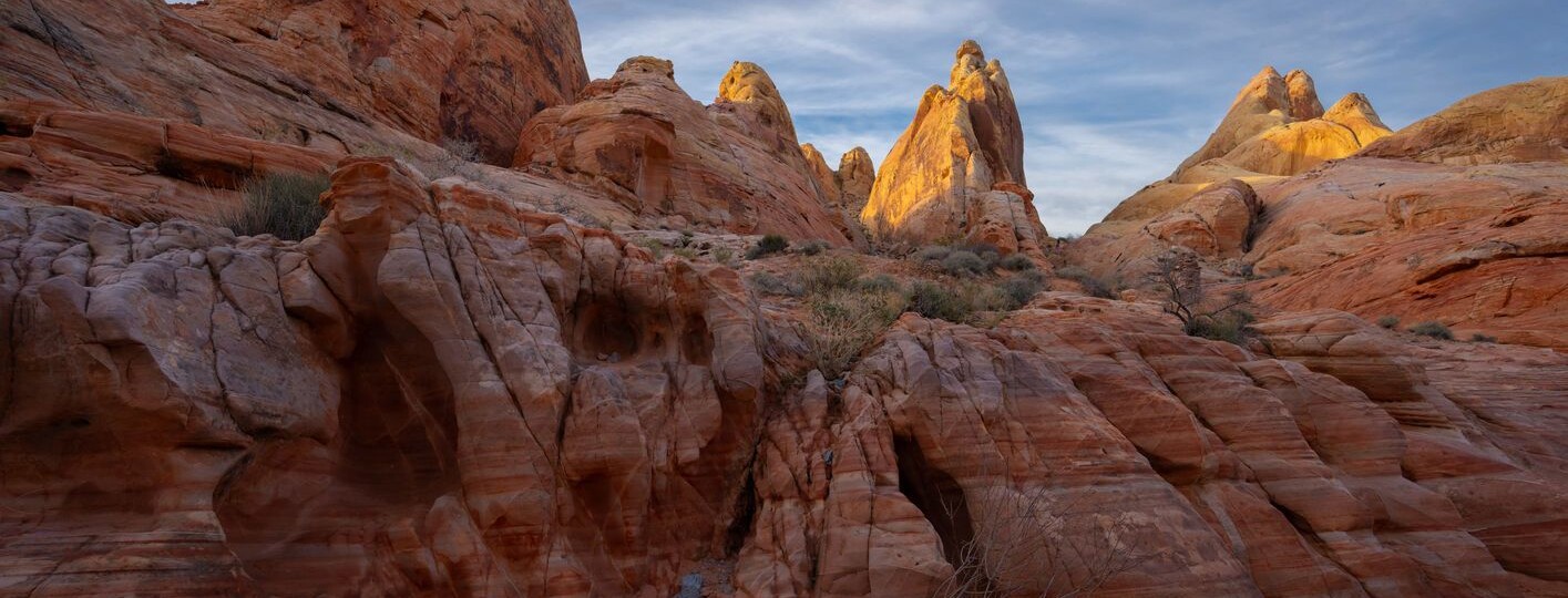
1. Fire Wave Trail, the most popular Valley of Fire hike
The Fire Wave Trail is one of the top hikes in the Valley of Fire, thanks to its gorgeous scenery. It’s a heavily trafficked route that’s good for all skill levels.
The Fire Wave trailhead is on the western side of Parking Lot #3. At the start, you’ll descend some sandstone ridges before hiking slightly uphill alongside White Domes Road. Then, the path evens out and curves past Gibraltar Rock.

1. Fire Wave Trail, the most popular Valley of Fire hike
At this point, you’ll start seeing the slickrock’s interchanging streaks of beige, orange, and red. After about a half-mile, you’ll reach a depression where you can get a nice view of these wavy striations. Once you reach the Fire Wave, take in its natural beauty, paying special attention to the most impressive stripes on the west side.
The Valley of Fire wave hike is the one we did when we took a Valley of Fire tour from Las Vegas. So, if you don’t want to drive to the state park, I recommend booking this tour.
- Duration: 45 minutes
- Distance: 1.5 miles
- Difficulty: Easy
- Route type: Out & Back
- Obstacles: Descent to depression bowl
- Elevation gain: 236 ft
2. White Domes Trail, another awesome hike in the Valley of Fire
Another scenic Valley of Fire hike is the White Domes Trail. The route is just over a mile long and gets plenty of foot traffic, so it’s good for kids. This loop trail will take you past various geological formations and beautiful vistas.
The trailhead is on White Domes Road, and immediately, you’ll hike through lovely sandstone structures. As you descend a slight slope, you can see a range of rock formations and different-colored domes. You’ll have to ascend some stone steps that are part of a large boulder, then walk down to an open amphitheater area with old movie set ruins.

2. White Domes Trail, another awesome hike in the Valley of Fire
Continue through a slot canyon and make it out on the other side as you hike past even more impressive rock structures, arroyos, and the White Domes. If you want, you can link to the Fire Wave Trail and do the Seven Wonders Loop, a trail I’ll talk about next.
If you’d like to do this route, download our Valley of Fire White Domes Trail map below!
- Duration: 30 minutes
- Distance: 1.1 miles
- Difficulty: Easy
- Route type: Loop
- Obstacles: Stone steps
- Elevation gain: 177 ft
3. Seven Wonders Loop, an interesting Valley of Fire hike to do
If you want to see several stunning sights on one hike, the Seven Wonders Loop is for you. As the name suggests, this route takes you on a journey to see some of the most wonderful aspects of the park, making it one of the best Valley of Fire hikes.
That said, this hiking trail in the Valley of Fire is relatively unknown and not listed on many visitor guides. If you want to do this route, I suggest downloading our trail map, so you don’t get lost. Also, you can combine this route with the White Domes Trail, which will add about another hour to the loop.

3. Seven Wonders Loop, an interesting Valley of Fire hike to do
The Seven Wonders Trail begins at the parking lot on White Domes Road (also called Mouse’s Tank Road). From there, the path travels southwest, past the Fire Cave, Thunderstorm Arch, and Crazy Hill. As you trek through the White Domes, you’ll arrive at the Kaolin Wash, which will lead you to Striped Rock and the Pink Canyon.
The last wonder you’ll see is the Fire Wave, a short Valley of Fire hike I mentioned earlier.
- Duration: 2 hours
- Distance: 1.8 miles
- Difficulty: Intermediate
- Route type: Loop
- Obstacles:
- Elevation gain: 193 ft
4. Petroglyph Canyon via Mouse’s Tank Trail, an easy Valley of Fire trail you shouldn’t miss
Mouse’s Tank offers some of the best hiking near Las Vegas because of all the petroglyphs. In fact, visiting Petroglyph Canyon via the Mouse’s Tank Trail is one of the most popular routes, especially for families.
The trailhead is a bit south of the Petroglyph Canyon Parking Lot. You’ll hike through a canyon wash and pass several examples of ancient Native American rock art.

4. Petroglyph Canyon via Mouse’s Tank Trail, an easy Valley of Fire trail you shouldn’t miss
The tail end of the trail curves to the left and ends at Mouse’s Tank. This natural basin is named after a Paiute Indian nicknamed Mouse, who used the basin as a watering hole while hiding out in the canyon.
Given its excellent collection of petroglyphs and the easy terrain, this is one of the best Valley of Fire trails for kids. Of course, all ages will enjoy the hike!
- Duration: 45 minutes-1 hour
- Distance: 0.8 miles
- Difficulty: Easy
- Route type: Out & Back
- Obstacles: None
- Elevation gain: 55 ft
5. Rainbow Vista Trail, the best hike in Valley of Fire for incredible views
The Rainbow Vista Trail at Valley of Fire is a colorful experience that you won’t forget. You can find the trailhead at the parking lot on Mouse’s Tank Road, just south of Fire Canyon Road.
Right from the start, you’ll get incredible views of the surrounding landscape of reds, pinks, oranges, yellows, greens, and whites. The sweeping vistas reveal millions of years of erosion and oxidation, as seen in the canyons, ridges, and valleys along the trail.

5. Rainbow Vista Trail, the best hike in Valley of Fire for incredible views
After hiking past large sandstone formations, you’ll walk through the open desert, then climb to the Rainbow Vista crest and take in the views. The last part of this Valley of Fire hiking trail takes you to the Fire Canyon Overlook, another gorgeous vista.
Parts of the trail lack signage, and you’ll have to traverse some uneven terrain. However, the route is quite easy and will reward you well.
- Duration: 45 minutes
- Distance: 1.1 miles
- Difficulty: Easy
- Route type: Out & Back
- Obstacles: Uneven terrain
- Elevation gain: 95 ft
6. Elephant Rock Loop, one of the best Valley of Fire hikes to do with kids
If you’re visiting the park with kids, the Elephant Rock Loop should be on your list. It’s a simple walk that leads to one of the most prominent geological structures in the Valley of Fire.
Elephant Rock is an obvious sandstone formation that delights visitors of all ages. Its unmistakable shape is quite impressive, and it doesn’t take much imagination to see the elephant’s trunk and thick body. While you can see it from the Scenic Drive Road, you’ll get the best views if you do the hike. Just be mindful of the lizards and snakes in the area.

6. Elephant Rock Loop, one of the best Valley of Fire hikes to do with kids
This attraction is close to the park’s east entrance, so you shouldn’t have any problems finding it. Plus, it’s a short and sweet Valley of Fire hike that you can do with small children.
- Duration: 20 minutes
- Distance: 0.3 miles
- Difficulty: Easy
- Route type: Out & Back
- Obstacles: Snakes
- Elevation gain: 52 ft
7. Prospect Trail, a rewarding Valley of Fire hike
If you’re an experienced hiker and want to get off the beaten path, check out the Valley of Fire Prospect Trail.
This off-road trail in the Valley of Fire is between the main highway and White Domes. You could even tack on the White Domes Loop when you get to the end of the Prospect Trail. That said, this route is already pretty long, and it’s a rewarding trek through some fascinating scenery.

7. Prospect Trail, a rewarding Valley of Fire hike
While much of the trail goes through a wash, you’ll also see a wide range of desert flora and fauna. Keep an eye out for bighorn sheep and rattlesnakes!
The various rock formations are also beautiful, and they span the size and color spectrum, including red, orange, yellow, gray, and white. It’s a truly amazing trail, but there is no water or shade along the route, so come prepared.
- Duration: 4 hours
- Distance: 8.8 miles
- Difficulty: Difficult
- Route type: Out & Back
- Obstacles: Elevation gain, rattlesnakes
- Elevation gain: 800 ft
8. Natural Arches Trail, another beautiful Valley of Fire hiking trail
The Valley of Fire’s Natural Arches Trail is a pleasant route you should consider if you want a peaceful hike. As the name suggests, you’ll find natural arches along the route, but other sights as well. The trail’s namesake arch has since collapsed, but there are several others that you can see.
Besides the arches, this Valley of Fire hike is known for its geological beauty. You’ll hike through a wash and some lovely desert scenery with hints of color from the wildflowers and rock structures. Much of the path is sandy, making the terrain uneven, but the white sand against the pink canyon walls is exquisite.

8. Natural Arches Trail, another beautiful Valley of Fire hiking trail
Like the Prospect Trail, this route is mostly unmarked, so be sure to download the trail map below. If you use the park’s east entrance, you’ll find the trailhead shortly after you pass the Elephant Rock Trailhead along the Scenic Drive. You should see a sign indicating the Natural Arches Trail to the north and Charlie’s Spring to the south.
- Duration: 2 hours
- Distance: 4.2 miles
- Difficulty: Intermediate
- Route type: Out & Back
- Obstacles: Uneven terrain
- Elevation gain: 229 ft
9. Pinnacles Loop, another Valley of Fire hike you should do
Pinnacles Loop is another off-road trail in the Valley of Fire that takes you off the beaten path. This hidden gem offers a unique landscape of rugged pinnacles and beautiful views, so don’t pass it up!

9. Pinnacles Loop, another Valley of Fire hike you should do
The first half of this hike is sandy and rocky, but it’s worth the effort, and the trail is well-marked. Once you reach the pinnacles, take some time to admire the jumble of rocky peaks and the intricate shapes. You’ll see pretty rock formations striped in red and purple, as well as a variety of cacti.
The last part of this loop requires a bit of scrambling, but it’s not bad.
- Duration: 2.5 hours
- Distance: 4.8 miles
- Difficulty: Intermediate
- Route type: Loop
- Obstacles: Uneven terrain, snakes
- Elevation gain: 429 ft
10. Balancing Rock Trail, another short Valley of Fire hike you’ll enjoy
Finally, the Balancing Rock Trail is a short and easy loop that you can find right outside the Visitor Center. This Valley of Fire trail leads to one of the park’s most popular formations, Balanced Rock.

10. Balancing Rock Trail, another short Valley of Fire hike you’ll enjoy
Follow this narrow path as it guides you around this impressive structure. You’ll be able to see the rock from all angles, and you can find petroglyphs along the way, too. The route is very easy, with only the slightest elevation change, so it’s great for families and inexperienced hikers. Plus, it’s right off the main highway, so you can drive up Mouse’s Tank Road afterward to explore the other hikes I mentioned earlier.
- Duration: 15 minutes
- Distance: 0.3 miles
- Difficulty: Easy
- Route type: Out & Back
- Obstacles: None
- Elevation gain: 3 ft
Valley of Fire hiking tips
Now that I’ve shared the best Valley of Fire trails, here are some tips to keep in mind during your visit:
- The park is typically hot and dry, so prepare for the weather. Wear loose-fitting, light-colored clothing and hiking boots or shoes. Sunglasses, a hat, and sunscreen are also essential.
- Bring lots of water and snacks; you’ll want to stay hydrated the entire time. Be aware that there is little shade and no water along these routes.
- Download theValley of Fire hiking map below and keep it on your phone. This way, you can access it even if you don’t have cell service. It’ll be particularly useful if you take one of the unmarked trails.
Follow these tips and you’ll have a great time hiking in the Valley of Fire!
Valley of Fire trail map
Last but not least, I’d like to share this Valley of Fire trail map so you can easily plan your hiking itinerary. I recommend downloading it in the Maps.me app so you can keep it on your phone for quick access.
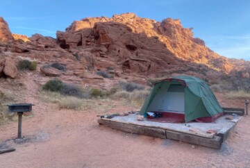
I hope you found a couple of hikes in the Valley of Fire that pique your interest! Remember that we have a complete guide to this state park as well as an article on camping in the Valley of Fire. That should cover everything you need to know for the perfect trip to this stunning area.
If you have any questions, feel free to leave me a comment below so I can help you out. Have a safe trip!