The casinos and shows in Sin City can be lots of fun, but when you need a nature break, consider taking a hike in Las Vegas. Believe it or not, there are lots of awesome hiking trails in the Las Vegas area, and lots of them are free. Sometimes, getting away from the noise and chaos of the Strip and reconnecting with the great outdoors is the best way to feel refreshed!
Even if you came to Vegas for the glitzy atmosphere and entertainment, I doubt you’ll regret going on a lovely hike. Besides, there are so many beautiful places to hike near Las Vegas, many of which are within an hour of the Strip. No matter your experience level, there is a great trail waiting for you!
In this guide, I’ll share the 10 best hikes in Las Vegas and a Las Vegas trails map you can download for reference. So, let’s get started!
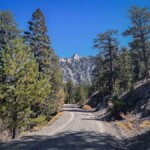
1. Calico Trails, the best hikes in Las Vegas
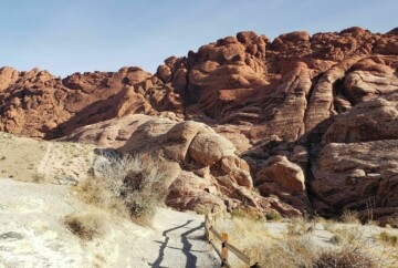
While we have another article on Red Rock Canyon hiking trails, I must mention the Calico Trails in this guide. Since it’s less than an hour from the Strip, Red Rock Canyon is one of the best places to visit near Las Vegas during the day. So, if you’re looking for a nearby spot to hike for a few hours, this is the place!
While you’re traveling along the park’s Scenic Loop Drive, you’ll pass a couple of Calico trailheads. You can hike the Calico Hills Trail from Calico Hills South or the shorter Calico Tanks Trail from the Sandstone Quarry Overlook.

1. Calico Trails, the best hikes in Las Vegas
First, Calico Hills is a difficult route with uneven terrain that requires some scrambling. It’s an enjoyable challenge, and you’ll see different colors, rock formations, and beautiful views of the hills.
Calico Tanks is just over 2 miles and a lovely adventure full of petroglyphs, an old agave roasting pit, and the Calico Basin. It’s an easier Las Vegas hike you can do with kids, and you’ll want to take your time and appreciate the sandstone structures.
|
|
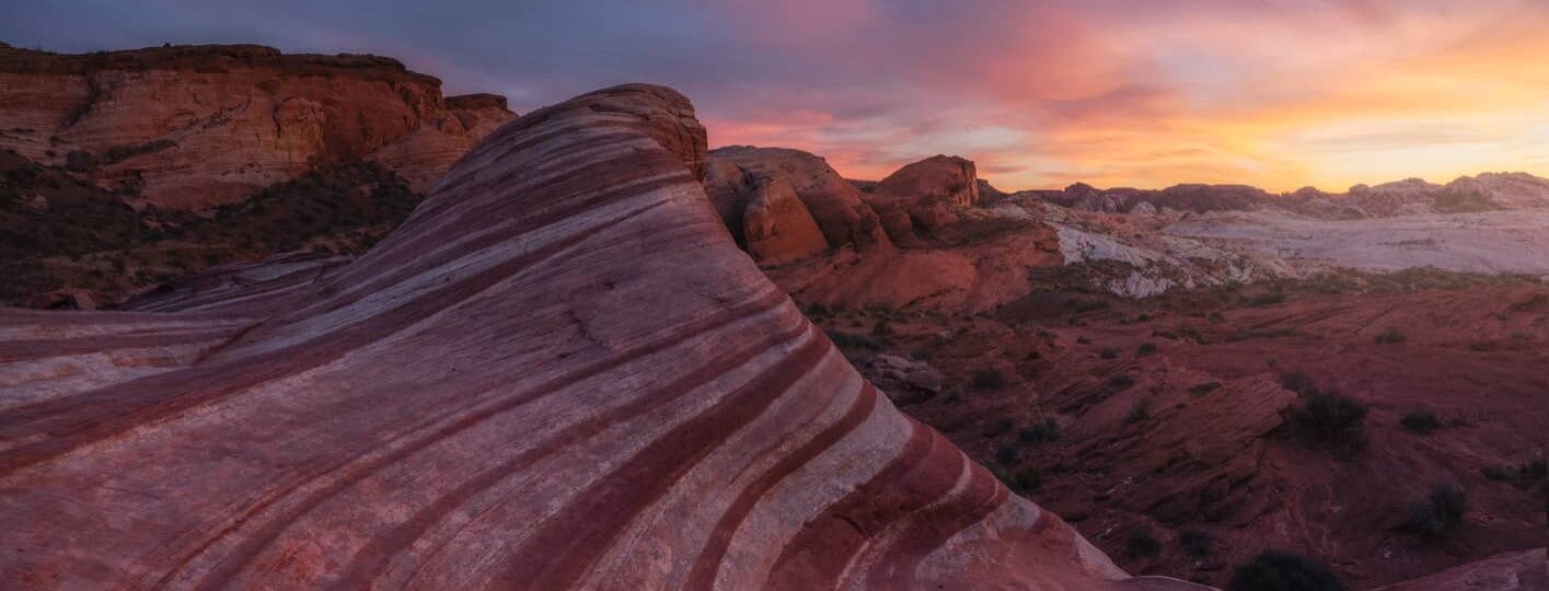
2. Fire Wave Trail, a well-known Las Vegas hike
One of the best routes is the Fire Wave Trail, a 1.5-mile hike through an impressive landscape in Valley of Fire State Park.
You’ll start at the trailhead on Mouse’s Tank Road, then embark on a trek through some of the most striking sandstone formations in the park. The undulating stripes of red, pink, and white make for a great photo op, too. Along with the stunning views and lookout points, you’ll pass interesting rock cairns.

2. Fire Wave Trail, a well-known Las Vegas hike
The trail is absolutely beautiful, and one of the top hikes in the Valley of Fire for sure. However, try to do this Las Vegas hike in the early morning or late in the day since the temps can soar to over 100° F and there is no shade.
- Duration: 1 hour
- Distance: 1.5 miles
- Difficulty: Easy
- Route type: Out & back
- Obstacles: No shade
- Elevation gain: 236 ft
3. Mary Jane Falls, a scenic hiking trail in Las Vegas
The Mary Jane Falls Trail is a great family hike near Las Vegas, Nevada, in Mount Charleston. It’s a very enjoyable and scenic route and, as the name suggests, has a waterfall. It’s a smaller waterfall, but the area around it has a pretty clearing with mountain views.

3. Mary Jane Falls, a scenic hiking trail in Las Vegas
Mary Jane Falls is one of the best hikes near Las Vegas to get away from the city, and it’s not too long. You’ll be surrounded by a gorgeous environment, including wildflowers, ponderosa pines, and natural springs. While the trail is easy to follow, it’s eroded in some areas and can get quite cold, so bring layers and good shoes.
- Duration: 2 hours
- Distance: 3.9 miles
- Difficulty: Intermediate
- Route type: Out & back
- Obstacles: Trail erosion, can get cold
- Elevation gain: 1,135 ft
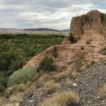
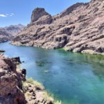
4. Arizona Hot Springs, one of the top Las Vegas hiking loops
If you’re going to visit the Hoover Dam, be sure to check out the Arizona Hot Springs Trail, which is just 15 minutes away. Spend a half-day exploring this scenic round-trip hike near Las Vegas, Nevada, taking in the changing landscape.

4. Arizona Hot Springs, one of the top Las Vegas hiking loops
This Las Vegas hike begins on US-93 and goes through a gravelly wash and slot canyons to a fork in the trail. The path to the right goes past Liberty Bell Arch; some people take this path and then backtrack, while others do the full loop around.
Once you reach the Colorado River on the Nevada-Arizona border, you can descend a ladder to get to the hot springs. It’s such a pretty place, but it can get crowded. Fortunately, the entire hike is beautiful, just very hot and a bit tricky in some parts.
- Duration: 6.5 hours
- Distance: 5.9 miles
- Difficulty: Difficult
- Route type: Loop
- Obstacles: Extreme heat in summer, ladder to hot springs
- Elevation gain: 1,223 ft
5. Bristlecone Trail, some of the best hiking in the Las Vegas desert
The Bristlecone Trail is another Mt. Charleston hike near Las Vegas that I highly recommend. This Las Vegas nature trail is in the Spring Mountains National Recreation Area and can start from the Lower Bristlecone or Upper Bristlecone Trailhead.
The upper trail is not as well-marked as the lower trail, and it’s narrower and rockier, so wear good shoes. On the other hand, the upper trail is more scenic, so don’t miss out!

5. Bristlecone Trail, some of the best hiking in the Las Vegas desert
This circular route offers some of the best hiking near Las Vegas because you can watch for birds, wildlife, and the Mt. Charleston Blue Butterfly. You’ll also see different natural scenery, like aspen groves, dense forests, mountain ridges, ponderosa pines, and bristlecones. There is a seasonal creek in the spring, and the trail is in Lee Canyon, where you can find other outdoor areas and activities.
- Duration: 2.5 hours
- Distance: 5.7 miles
- Difficulty: Intermediate
- Route type: Loop
- Obstacles: Ascent back to the parking lot
- Elevation gain: 931 ft
6. Petroglyph Canyon Trail, a fun Las Vegas hiking trail
The Petroglyph Canyon Trail is a fun loop hike near Las Vegas you can do as a family. Plus, it’s in Sloan Canyon National Conservation Area, which is just 30 minutes from the Strip and a great place to go outside Las Vegas.
At just over 4 miles, this route is an enjoyable way to explore Sloan Canyon and see the pictographs that make this area so famous. The elevation gain isn’t bad, but the terrain is rocky and requires some scrambling. You can take a more straightforward path to the petroglyphs by following the 200 trail that runs parallel to this one.

6. Petroglyph Canyon Trail, a fun Las Vegas hiking trail
If you take the 100 trail (as listed on the map), you’ll have to scramble over some dry falls and traverse some soft ground, but it’s a fun hike, and the views are great. This is also one of the best hiking trails in Las Vegas if you want to spot bighorn sheep.
- Duration: 2 hours
- Distance: 4.1 miles
- Difficulty: Intermediate
- Route type: Loop
- Obstacles: Uneven terrain, scrambling
- Elevation gain: 557 ft
7. White Owl Canyon, an awesome Las Vegas hike through a slot canyon
White Owl Canyon gets its name from the white owls you can see in the slot canyons along the route. So, keep your eyes peeled! This Las Vegas trail is next to the Las Vegas Bay, west of Lake Mead National Recreation Area.
There are hilly portions along the trail, particularly at the beginning and end. However, once you reach the slot canyon, it’s shady, cool, and quite scenic. You’ll want to veer left at the fork in the trail to descend into the canyon and avoid climbing some steep cliffs.

7. White Owl Canyon, an awesome Las Vegas hike through a slot canyon
After hiking through the canyon, you’ll reach Lakeshore Road, which you’ll cross before continuing through a gravel wash. While parts of the trail aren’t well-marked, it’s a suitable route for beginner or intermediate hikers and a beautiful way to spend your morning.
- Duration: 2.5 hours
- Distance: 3.6 miles
- Difficulty: Intermediate
- Route type: Loop
- Obstacles: Not clearly marked in some spots
- Elevation gain: 318 ft
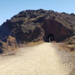
8. Railroad Tunnel Trail, an easy hike in Las Vegas for families
Another awesome Las Vegas hiking trail near Lake Mead is the Railroad Tunnel Trail.
The trailhead is next to the Lake Mead Visitor Center on Lakeshore Road. This is a longer trail, but it’s well-marked and has sturdy gravel, so it’s good for all levels. The route runs parallel to Boulder City Highway, and you’ll pass all kinds of interesting sights along the way.

8. Railroad Tunnel Trail, an easy hike in Las Vegas for families
First, you’ll see the Hoover Dam’s construction tunnels, followed by the Lake Mead – Lakeview Overlook, where you can capture lovely photos. Continue east, and you’ll find the Hoover Dam Boneyard and eventually, the dam itself.
Overall, this is a fantastic Las Vegas trail with lots of history and scenery, so I’m sure you’ll love it. Just be sure to bring plenty of water since it gets hot out there. Still, it’s one of the best things to do in Nevada.
- Duration: 5 hours
- Distance: 8.2 miles
- Difficulty: Easy
- Route type: Out & back
- Obstacles: None
- Elevation gain: 931 ft
9. Lone Mountain Trail Hike, one of the best Las Vegas hiking loops
The Lone Mountain Trail Hike is another easy hike you could do with kids or pets. It’s shorter than the Railroad Tunnel Trail, and it’s 20-30 minutes from Sin City, so it’s a quick Las Vegas hike you can do.
Not only is this a gorgeous hiking trail in Las Vegas, but it takes you to a great sunrise spot at Lone Mountain Peak. If you can get there a bit before dawn, you can watch the sun creep up over the summit.

9. Lone Mountain Trail Hike, one of the best Las Vegas hiking loops
Even if you do this hike later in the day, it’s such a treat to explore Lone Mountain Regional Park. This is a beginner-friendly hike lined with wildflowers and lovely views, so don’t miss it. The only challenging parts are the ascent and descent, but the path is well-trafficked throughout.
- Duration: 45 minutes
- Distance: 2.2 miles
- Difficulty: Easy
- Route type: Out & back
- Obstacles: Ascent
- Elevation gain: 643 ft
10. Wetlands Park Nature Preserve Loop, another easy hike near Las Vegas, NV
Finally, the Wetlands Park Nature Preserve Loop is an awesome circular trail in Clark County, about a 20-minute drive from the Strip. It’s perfect for a quick nature fix, and since it’s mostly flat, it’s a great family-friendly trail.
Located in Clark County Wetlands Park, this off-road trail near Vegas goes past a few scenic ponds and the Las Vegas Wash. Depending on when you go, the wetlands may not be as wet, but the area is a popular bird-watching and wildlife-viewing spot, so keep an eye out.

10. Wetlands Park Nature Preserve Loop, another easy hike near Las Vegas, NV
You can hop on the trail right outside the Wetlands Visitor Center and choose the paved or unpaved path. What’s also nice about this route is that it’s accessible for those with mobility issues, and there are benches along the way. Just be aware that dogs aren’t allowed on this loop.
- Duration: 1 hour
- Distance: 2.1 miles
- Difficulty: Easy
- Route type: Loop
- Obstacles: None
- Elevation gain: 36 ft
There you have it, the 10 best hikes in the Las Vegas area! I hope you found at least one trail you’d like to check out. To help you plan your route, I’m sharing a Las Vegas trails map with all the hikes I mentioned. I recommend downloading the map and keeping it on your phone to access it even if you lose cell service.
If you have any questions or concerns about these hiking trails in Las Vegas, leave me a comment, and I’ll be happy to help. Have a safe trip!