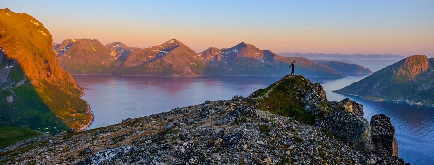
Hiking in Tromso is a fantastic way to explore the area and see the fjords, mountains, surrounding islands, and more. In fact, the Tromso region is home to many different trails, so it’s an ideal spot for hiking.
Best of all, many Tromso hikes are accessible year-round, so you can even hit the trails if you visit Tromso in winter. Just make sure that you have the appropriate gear, such as warm clothing and skis or crampons if it’s particularly snowy or icy.
Ultimately, hiking is considered one of the best things to do in Tromso for many reasons: the spectacular landscapes around Tromso; the fresh, crisp air; and the variety of Tromso hiking trails. You can find everything from glacier and mountain treks to rock scrambles and forest walks. Try out the routes below for yourself and experience Tromso’s natural beauty in all its glory.
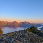
1. Fløya, hiking near Tromso with spectacular views
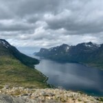
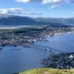
One of the best Tromso hikes is to Fløya, a mountain that provides panoramic views of the city, Kvaløya Island, and the fjords. There are three different routes you can take to get to the top.

1. Fløya, hiking near Tromso with spectacular views
The first and most popular route is up the Sherpatrappa, or “Sherpa Staircase,” a 1,003-step staircase built several years ago by Sherpas from Nepal. Since you’re ascending via stone steps, the climb is quite steep but is shorter than a more gradual ascent. This loop trail, which can be completed year-round, with skis or snowshoes in the winter, takes you to the top of Fløya and back down through a valley.
The second route starts from the lower cable car station, Fjellheisen. (If you’re looking for the easiest route of all, take the four-minute cable car ride up part of the mountain and then walk the rest of the way to Fløya’s summit.) You’ll walk up a steep forest trail to the cable car’s upper station and, from there, follow the trail to the top of Fløya.
Finally, the third route also starts from Fjellheisen and takes you up an almost straight path through Dalberstien to Fløya’s peak.
|
Trail 1 – Sherpatrappa og Dalbergstien (most popular route- route up Sherpa Staircase)
|
Trail 2 – Fløya via Dalbergstien (starts at lower cable car station, Fjellheisen)
|
Trail 3 – Fløya fra Fjellheisen dalstasjon (Fløya from Fjellheisen valley station- lower cable car station)
|
2. Rødtind, one of the best Tromso winter hikes
Yet another mountain that offers stunning views of the sea and surrounding area is Rødtind. Although the hike to Rødtind’s peak can be done at any time of year, the mountain is still one of the most popular spots for Tromso winter hikes and for skiing and snowboarding.

2. Rødtind, one of the best Tromso winter hikes
A Tromso rental car is the easiest way to get to Rødtind, since you’ll reach the trailhead after driving only 15 minutes from Tromsø city center. The trail begins with an easy stretch to a bridge over Storelva. After you pass a mooring area, you’ll continue climbing on a well-marked path. The entire trail is uphill, but the last portion gets particularly steep, so be prepared to reach the top and be out of breath.
Still, a little sweat and breathlessness is worth it when you have such incredible views from the summit as your reward.
- Duration: 2 to 3 hours
- Distance: 4.8 km/3 miles
- Difficulty: Hard
- When to do it: Year-round (can use snowshoes or skis in the winter)
- Type: Out & Back
- Obstacles: Weather – ice/snow in winter, mud
- Elevation gain: 427 m/1,401 feet
3. Topptur til Store Blåmann, a challenging Tromso hike
Many of the Tromso hikes I’ve included on this list are suitable for all levels of hiking ability. However, the hike to Topptur til Store Blåmann is one I would only recommend for very experienced hikers and climbers, since Store Blåmann is Kvaløya’s highest and most difficult peak to climb.

3. Topptur til Store Blåmann, a challenging Tromso hike
Much of the route involves rock climbing and scrambling, so it’s a physically demanding trek. The trail starts out on easy terrain, but you’ll quickly reach the rocky portion, which, at a certain point, entails navigating a sheer, vertical rock wall (not for the faint of heart!).
Luckily, the last section of the trail is relatively easy, especially after you’ve completed the rock-climbing part, and the incredible views, of course, make the climb worth it. Still, you should only attempt this hike if you have the proper equipment and experience and it hasn’t rained recently, since the rocks can be extremely dangerous when slippery.
- Duration: 3 to 5 hours
- Distance: 6.3 km/3.9 miles
- Difficulty: Hard
- When to do it: May to August, as long as there is no snow and the conditions aren’t wet, since the rocks can get slippery
- Type: Out & Back
- Obstacles: Rocky terrain that involves scrambling/climbing, sheer rock wall, weather
- Elevation gain: 1,004 m/3,294 feet
4. Nattmålsfjellet, Tromsø hiking with views of the fjords
Admire the majestic fjords from the peak of Nattmålsfjellet, a mountain on Kvaløya Island with two different ways to hike it.

4. Nattmålsfjellet, Tromsø hiking with views of the fjords
The more popular Tromso hiking route is via the Ersfjord side of the mountain. This somewhat steep loop path takes you up and around Nattsmålsfjellet before leading you back down to where you started.
On the other hand, the Kattfjordeidet route, which takes you up the other side of the mountain, is a much easier trail. The path is well marked and not steep but can be rocky and muddy, particularly if it has rained recently.
|
Trail 1 – Ersfjordbotn til Nattmålsfjellet
|
Trail 2 – Kattfjordeidet to Nattmålsfjellet
|
5. Brosmetinden, a relatively easy Tromso hike
If you’re looking for a short and easy hike that still offers impressive views, the trail to Brosmetinden is perfect. The trailhead is only a one-hour drive from downtown Tromso, and the walk is suitable for hikers of all ages and abilities.

5. Brosmetinden, a relatively easy Tromso hike
Best of all, you’ll enjoy panoramic views throughout this hike in Tromso, so you can always turn around before you reach the summit. To get to the top of Brosmetinden, you’ll follow a path along the south ridge, which starts at a steady, gradual incline before getting a bit steeper as you approach the summit.
Once you reach the top, you’ll be able to take in gorgeous views of the sea and other mountains in the area. If you visit Tromso in summer, this is the ideal place to watch the midnight sun illuminate the landscape.
- Duration: 1 to 2 hours
- Distance: 3.9 km/2.4 miles
- Difficulty: Easy
- When to do it: All year round
- Type: Out & Back
- Obstacles: Weather, mud
- Elevation gain: 221 m/725 feet
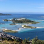
6. Ørnfløya, scenic hiking near Tromso
With an elevation gain of only 325 feet (99 meters), Ørnfløya is probably closer to a hill than a mountain, but you’ll still feel a sense of accomplishment from completing this easy hike. After all, at the top, you’ll get views of the fishing village of Sommarøy; the islands of Hillesøy, Senja, and Håja; and other smaller islands and reefs.

6. Ørnfløya, scenic hiking near Tromso
This is some of the best hiking near Tromso, since the path is not steep and is very well marked. Moreover, like Brosmetinden, the hike to Ørnfløya is well suited for hikers of all ages and abilities.
- Duration: 1 hour
- Distance: 1.9 km/1.2 miles
- Difficulty: Easy
- When to do it: All year round (can use snowshoes or skis in the winter)
- Type: Out & Back
- Obstacles: Weather, mud
- Elevation gain: 118 m/387 feet
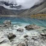
7. Blåvatnet, one of the best easy Tromso hikes
Take the road less travelled to Blåvatnet and marvel at an intensely blue lake surrounded by mountains, a view you certainly won’t want to miss. This Tromso hiking trail tends to be much less busy than some of the other ones I’ve listed, so it’s the best option if you want quiet and solitude while you explore nature.

7. Blåvatnet, one of the best easy Tromso hikes
The path to the lake mostly consists of alternatively flat terrain and slight inclines, but the last stretch of the trail has some boulders and rocks you’ll need to climb over (nothing too difficult, though!). The red markers along the path will ensure that you don’t get lost on your way to this fairy-tale location.
- Duration: 2 to 4 hours
- Distance: 9 km/5.5 miles
- Difficulty: Moderate
- When to do it: All year round
- Type: Out & Back
- Obstacles: Rocky terrain
- Elevation gain: 223 m/731 feet
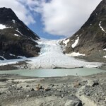
8. Steindalsbreen, the best Tromso glacier hike
If you’re dying to do a Tromso glacier hike, look no further than this trek to the Steindalsbreen glacier. This hike, which is considered moderate, takes you through the Steindalen valley, where you’ll find signposts about the wildlife, plants, and history of the area.

8. Steindalsbreen, the best Tromso glacier hike
The trail is relatively flat until you reach the moraine ridge, where the path steepens before flattening out just before the base of the glacier. Once you’ve arrived at the glacier, take a moment to admire its infinitesimal cracks and various hues of blue. After all, it’s not every day that you can get this close to such an incredible natural wonder.
- Duration: 4 to 5 hours
- Distance: 11.9 km/7.4 miles
- Difficulty: Moderate
- When to do it: July to October
- Type: Out & Back
- Obstacles: Weather – may need crampons if the trail is icy
- Elevation gain: 533 m/1,748 feet
I hope you feel ready to tackle one of the many Tromso hiking trails this area has to offer. Before you embark on your trekking adventure, don’t forget to download the Tromso map for the trail you’re doing. Most importantly, be sure to dress in layers, bring water, and wear sturdy boots.
If you want to see where hikes in Tromso are in relation to the city, this Tromso hiking map will help you situate yourself.
Also, if you want to sleep under the stars, there are plenty of great Tromso camping spots where you can end your day.
Happy hiking!