When traveling abroad, get a policy from one of the best travel insurance companies. Get a 5% discount on Heymondo, the only insurance that pays all medical bills upfront for you, HERE!
Hiking in Iceland is one of the most incredible activities you can do, especially if you love to be in nature.
There are many beautiful places to see on the island, and many of them can only be reached on foot, which is why there are lots of hiking trails in Iceland. Moreover, the trails here range in length and difficulty, so you will surely find one that suits your physical ability and interests.
If you want to enjoy a day hike in Iceland but don’t know where to start, in this guide you will find the best trails. I’ll also give you all the information you need so you can organize your trip and enjoy your adventure to the fullest.
1. Laugavegur, the most famous hike in Iceland
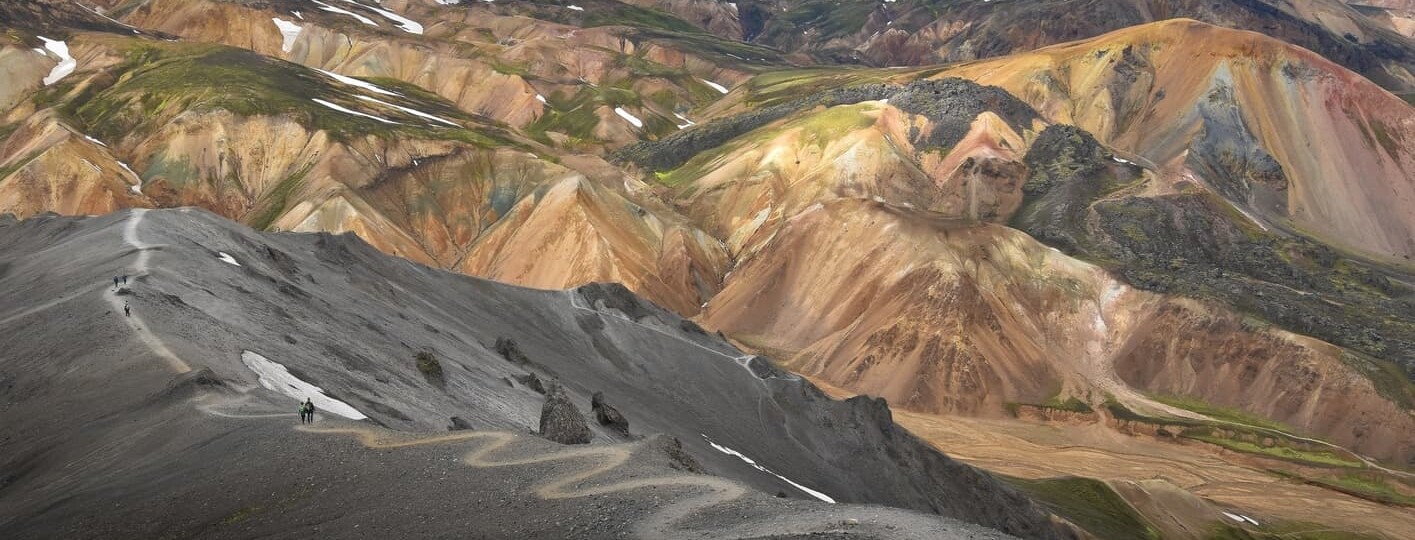
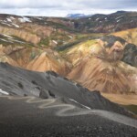
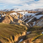
Of all the hiking trails in Iceland, Laugavegur, also known as the Landmannalaugar Trek, is the most popular and one of the longest. The trail goes from Landmannalaugar to Thórsmörk in the Highlands, and if this hike is known for anything, it’s the variety of landscapes.
In addition to seeing the famous and colorful Brennisteinsalda mountain, you’ll pass through the geothermal area of Stórihver and the black volcanic ash desert of Mælifellssandur. You can also marvel at the Markarfljótsgljúfur canyon before reaching Thórsmörk, the incredible and remote valley where the route ends.

1. Laugavegur, the most famous hike in Iceland
Along the trail, you’ll find numerous mountain huts and camping areas in Landmannalaugar, Hrafntinnusker, Álftavatn, Hvanngil, Emstrur, and Thorsmörk, but you must book months in advance because beds are very limited. If you decide to camp, you should only do so in designated areas, as we explain on our guide on camping in Iceland.
With a distance of 34 miles, this one-way trail can take between 3 and 4 days, so it’s best to get an Iceland On Your Own Hiking Pass to arrange the shuttle between the route’s start and end-points.
Some hikers connect this route to the Fimmvörðuháls trail, which adds 2 more days and takes you from Thórsmörk to Skógar.
- Duration: 3-4 days
- Distance: 34 miles
- Difficulty: Moderate
- When to go: May-September
- Route type: One-way
- Obstacles: Weather, the elevation gain at Hrafntinnusker and Álftavatn (4,200 ft)
- Elevation: Up to 4,265 feet
2. Fimmvörðuháls, one of the most popular hiking trails in Iceland
Another popular hiking trail in Iceland is the Fimmvörðuháls, which runs from Thórsmörk to Skógar. Many travelers hike it along with Laugavegur, although it can also be done independently, and this is an ideal alternative for those who enjoy long routes but are short on time.
The trail is between the Eyjafjallajökull and Mýrdalsjökull glaciers and ends at the Skógafoss waterfall, considered to be one of the most beautiful waterfalls in Iceland. Throughout the hike, you’ll see many other waterfalls and the Magni and Móði craters, as well as impressive landscapes with geology that looks out of this world.

2. Fimmvörðuháls, one of the most popular hiking trails in Iceland
One of the most interesting parts of this route is the ascent to Fimmvörðuháls. Here, you’ll see the green moss disappear, gradually being replaced with snow. I assure you it’s one of the best hiking trails in Iceland and one of the most popular ones.
Along the route, you will find different huts where you can spend the night. One of them is the Baldvinsskáli hut, and the other is the Utivist, which I recommend booking months in advance since they tend to fill up very quickly. If you decide to spend the night in Thórsmörk, I recommend staying at the Volcano Huts.
- Duration: 1-2 days
- Distance: 15.5 miles
- Difficulty: Difficult
- When to go: May-September
- Route type: One-way
- Obstacles: Ascent to Fimmvörðuháls
- Elevation: Up to 4,230 ft
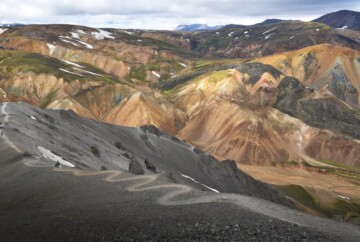
3. Brennisteinsalda-Bláhnúkur, the best one-day hike in Landmannalaugar
If you only have one day and want to enjoy hiking in Iceland, you can do the Brennisteinsalda-Bláhnúkur loop.
The route starts at Landmannalaugar towards Bláhnúkur, whose name means blue mountain. It is 3,080 feet high and from its summit, you get incredible views of the surroundings. When you leave this volcano behind, you’ll head towards Brennisteinslada.

3. Brennisteinsalda-Bláhnúkur, the best one-day hike in Landmannalaugar
Brennisteinslada, although it doesn’t stand out for its height, is an easily recognizable mountain due to its colorful appearance: sulfuric yellows, mossy greens, and blacks and blues from the volcanic ash. So, if you’re looking for a day hike in Iceland, I recommend this one, which will introduce you to an incredible part of the Icelandic Highlands.
In addition to Bláhnúkur and Brennisteinslada, you’ll find rivers, lava fields, and spectacular landscapes along this route. Also, if you spend the night in Landmannalaugar, you can enjoy its many hot springs.
- Duration: 4-5 hours
- Distance: 6 miles
- Difficulty: Difficult
- When to go: May-September
- Route type: Loop
- Obstacles: Ascent and descent to Bláhnúkur
- Elevation: Up to 2,080 ft
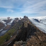
4. Kristínartindar via Svartifoss, one of the best hiking routes in Iceland
Kristínartindar via Svartifoss is another highly recommended hiking route in Iceland, as it takes just 6 hours to complete and passes through some of the best places to visit in Iceland.
The route is very close to Skaftárhreppur and passes through the Skaftafell National Park, where you can see the Svartifoss waterfall. It’s known as the black waterfall of Iceland because it cascades over basalt columns. Along the route, you can also appreciate the Morsárfoss waterfall in the distance, which is the tallest in the country.

4. Kristínartindar via Svartifoss, one of the best hiking routes in Iceland
Another awesome thing about this Icelandic hiking trail is that it offers spectacular views of the Skaftafellsjökull glacial tongue and the Vatnajökull glacier, which is the largest in Iceland. Plus, you can enjoy beautiful mountainous and natural landscapes, where both vegetation and snow cover the terrain.
- Duration: 1 day
- Distance: 11 miles
- Difficulty: Difficult
- When to go: Year-round
- Route type: Loop
- Obstacles: Uneven terrain
- Elevation: 3,280 ft
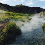
5. Reykjadalur, the most rewarding hike in Iceland
If you’re looking for an easy hike in Iceland that combines beautiful landscapes with relaxing hot springs, I recommend Reykjadalur.
This out & back trail is quite close to Reykjavík, the capital of Iceland, specifically in Hveragerði. The route runs through one of Iceland’s most active and popular geothermal areas, the Reykjadalur Valley. Here, you will find several Icelandic hot springs, although the most popular place to bathe is in the river. The bathing area is located about 10 feet from the Hveragerði car park, and it even has some privacy dividers so you can change into your bathing suit.

5. Reykjadalur, the most rewarding hike in Iceland
While the idea of soaking in these hot springs in winter is very attractive, I advise you to be very careful because there is usually ice along the way.
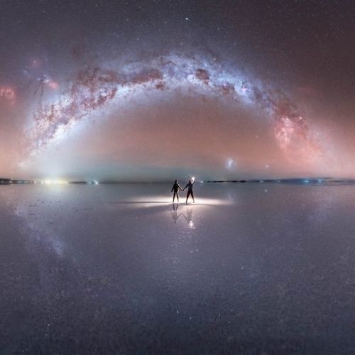
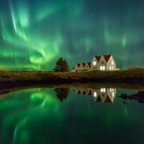
Besides, the Reykjadalur route is also ideal for enjoying the Northern Lights, so it’s a must-hike if you travel to Iceland between late August and mid-April. Also, I recommend checking out our guide on the best time and places to see the Northern Lights in Iceland.
- Duration: 2-3 hours
- Distance: 4 miles
- Difficulty: Easy
- When to go: Year-round
- Route type: Out & Back
- Obstacles: Ice in winter
- Elevation: 985 ft
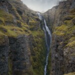
6. Glymur Waterfall, a beautiful and easy hike in Iceland
The Glymur waterfall is one of the tallest waterfalls in Iceland at over 650 feet, so taking the walking trail to it is quite an experience. However, this is one of the Icelandic hiking trails that you can’t do in the winter because you have to cross the river.
The best parts of this route are the views of the waterfall and the surrounding landscape and the challenges along the way. One of these obstacles is a log that you use as a bridge to cross the river, and the other is a fairly steep section that you climb up using the thick rope that’s fixed into the ground.

6. Glymur Waterfall, a beautiful and easy hike in Iceland
Once you get over these two obstacles, it’s time to enjoy the incredible views from the Hellupalur viewpoint, where you can see the Glymur waterfall. This Iceland hiking route is worth it because once you reach the point where the waterfall begins, you can see the majestic cascading water from different perspectives.
- Duration: 4 hours
- Distance: 4 miles
- Difficulty: Moderate
- When to go: Spring/summer
- Route type: Loop
- Obstacles: River crossing
- Elevation: 1,312 ft
7. Mount Esja, one of the best hikes near Reykjavík
Mount Esja is about 6 miles from Reykjavík, within the Kjalarnes district. Around Mount Esja, which is actually a volcano, there are several hiking trails, although one of the most popular is the 5-mile loop trail that offers beautiful views of the city and the surrounding area.

7. Mount Esja, one of the best hikes near Reykjavík
In winter, hikers usually finish the route on the Steinn, a large rock, while in summer they usually complete the loop and reach the top of the Þverfellshorn. The surrounding area is a mountain range overlooking the capital and the ocean, so it’s one of the most beautiful Iceland hikes near Reykjavík.
- Duration: 5-6 hours
- Distance: 5 miles
- Difficulty: Moderate
- When to go: Year-round
- Route type: Loop
- Obstacles: Ascent to Þverfellshorn
- Elevation: 2,370 ft
8. Hornstrandir Nature Reserve, the best Iceland Westfjords hiking trail
If you want to know the Westfjords, I definitely recommend the hiking route through the Hornstrandir Nature Reserve, which covers about 6,245 ft². You can only visit it during the summer months, by booking a boat ride here or here. Keep in mind that there are no accessible roads to this place since it’s in a remote area, so you’ll have to bring enough food and water to safely complete this Iceland hike.
That said, I can assure you that it’s one of the best areas for hiking since there is nothing more natural and wilder than the fjords of northwest Iceland. Here you can spot birds, arctic foxes, whales, and other animal species.

8. Hornstrandir Nature Reserve, the best Iceland Westfjords hiking trail
While there is plenty to see in this nature reserve and many hiking trails, some of the most interesting areas are Hornbjarg and the Kálfatindar cliffs. The most popular trail is the one that passes through Hesteyri, Hornvík, and Lónhorn, which have several hot springs and a spectacular landscape. The route through Tjaldsvæði Látrum and Reykjarfjörður offers some of the best Icelandic Westfjords hiking, although it’s a bit more complicated.
There are a few campsites in Hornstrandir Nature Reserve, and you can check all the camping areas and routes on this map.
- Duration: 6 days
- Distance: 50 miles
- Difficulty: Difficult
- When to go: Summer
- Route type: One-way
- Obstacles: Uneven terrain
- Elevation: 11,685 ft
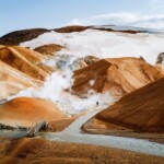
9. Hveradalir (Kerlingarfjöll), one of the best hikes in the Highlands of Iceland
The Highlands of Iceland are one of the most remote and wildest areas, so they have some of the most impressive landscapes in the country. After reading our guide to the Icelandic Highlands, I recommend doing the Hveradalshnukur hiking route, which goes from the Kerlingarfjöll mountain hut to the Hveradalir geothermal area. It is, by far, one of Iceland’s best hiking trails, and a popular self-guided route.
While you can get to Hveradalir by 4×4, I recommend taking the walking trail if you like hiking. The path is about 10.5 miles if you start at the resort, and it’ll allow you to get to know the Kerlingarfjöll area, a gorgeous mountain range with snow-capped peaks you can see year-round. There are also glaciers and a lot of geothermal activity, so you can see fumaroles, thermal rivers, and bubbling mud pools. The geothermal area of Hveradalir, which is where you’ll finish this hiking route, is one of the most impressive in the country.
, Iceland hiking map")
9. Hveradalir (Kerlingarfjöll), one of the best hikes in the Highlands of Iceland
I recommend spending the night in the Icelandic hiking huts at Kerlingarfjöll, from which you can enjoy other hiking trails in the area, some even longer, such as the one to the Austurfjöll peaks. Although this is only about 4 miles long, it’s very difficult since it ascends to different mountain peaks, such as Snaekollur, which is the highest in Kerlingarfjöll. There is also the route that surrounds Kerlingarfjöll, but you’ll need about 3 days to complete it since it’s nearly 30 miles.
- Duration: 5-6 hours
- Distance: 16.8 miles
- Difficulty: Moderate
- When to go: Summer
- Route type: Loop
- Obstacles: Uneven terrain
- Elevation: 1,885 ft
10. Stuðlagil Canyon, one of the most popular hiking trails in Iceland
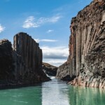
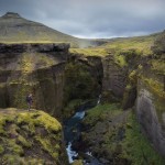
Another worthwhile hiking trail in Iceland is Stuðlagil Canyon, inside the Jökuldalur valley. This canyon is made of basaltic rock columns, creating one of the most beautiful landscapes on the island. Interestingly, the columns were hidden under the majestic blue waters of the Jökla glacial river until 2006, when the construction of a hydroelectric power station and reservoir lowered the water level.

10. Stuðlagil Canyon, one of the most popular hiking trails in Iceland
Although the north rim of this canyon is easily accessible by road, if you want to see the south rim, which is the most beautiful in my opinion, you’ll have to take a walking trail. It’s totally worth it since along the route you’ll see the Stuðlafoss waterfall, one of the best waterfalls in Iceland that you shouldn’t miss. This waterfall is located halfway along the route and stands out against the basalt columns.
- Duration: 4-5 hours
- Distance: 5.5 miles
- Difficulty: Easy
- When to go: Year-round
- Route type: Out & Back
- Obstacles: Uneven terrain
- Elevation: 155 ft
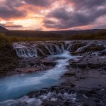
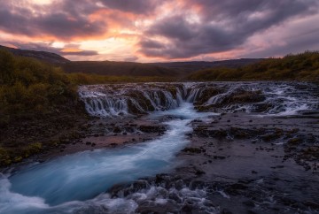
11. Brúarfoss, one of the best hiking tours in Iceland
Bruarfoss is one of the most beautiful waterfalls in Iceland and an essential stop if you’re exploring Iceland’s Golden Circle.
The waterfall used to be accessible by car, but ever since the road closed, travelers have to travel about 2 miles on foot, which considerably reduced the number of visitors. On the bright side, this made it one of the best day hikes in Iceland because it’s nice and quiet.

11. Brúarfoss, one of the best hiking tours in Iceland
You can leave your car in the designated parking lot on Road 37, then walk about 2 miles along the Brúarà river, which leads to the waterfall. If Bruarfoss is considered one of the most beautiful waterfalls in Iceland, it’s because of its stunning turquoise color., which earned it the nickname Blue Falls of Iceland.
It’s easy to get lost, so I recommend keeping this map of Iceland’s waterfalls with you.
- Duration: 4 hours
- Distance: 2 miles
- Difficulty: Moderate
- When to go: May-September
- Route type: Out & Back
- Obstacles: It’s easy to get lost
- Elevation: 1,490 ft
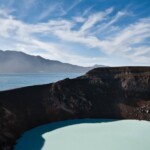
12. Vití & Askja volcano hiking in Iceland
The Askja volcano is located within the Icelandic Highlands, so you’ll need a 4×4 to get to the start of the hiking trail. This Iceland hiking route has become one of the most popular trails in the Highlands area.
The volcano sits in one of the most geothermally active regions in Iceland, but you can safely visit it without problems because it’s not expected to erupt anytime soon.

12. Vití & Askja volcano hiking in Iceland
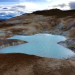
Also, the Vití thermal lake is in this area, inside a volcanic caldera. The lake’s waters have an average year-round temperature of 77° F, although bathing is discouraged until the end of July, which is when the thaw ends, and the area isn’t at an avalanche risk.
To get to this place, you’ll need a 4×4 because the F28 road is in poor condition and there are several rivers to ford. Once you reach the parking lot, you’ll have to walk a bit to get to the volcano and the lake. Without a doubt, this Iceland hike is well worth it because the landscape is magnificent.
- Duration: 5 hours
- Distance: 4 miles
- Difficulty: Moderate
- When to go: Summer
- Route type: Out & Back
- Obstacles: To get to the trailhead, you’ll need a 4×4 to ford some rivers
- Elevation: 540 ft
13. Leirhnjúkur Lava Field, a short-trafficked trail in Iceland
The lava fields are one of the most impressive landscapes on the island, so I recommend taking the hiking trail in Iceland that runs along the base of the Leirhnjúkur volcano.
This place isn’t crowded with tourists, so it’s perfect if you’re looking for some peace in nature. After a series of eruptions took place, parts of the ground cracked open and oozed lava, creating the lava fields that you can see here today.

13. Leirhnjúkur Lava Field, a short-trafficked trail in Iceland
While doing this Icelandic hike, you’ll notice steam coming out of the cracks, which creates an impressive scene. It’s worth noting that there is a small sulfuric lake in the area that gives off a rather unpleasant rotten egg smell, so be careful if you’re sensitive to this type of odor.
Depending on how much time you have, you can follow the path to the top of the Leirhnjúkur volcano.
- Duration: 4-5 hours
- Distance: 3 miles
- Difficulty: Moderate
- When to go: Year-round
- Route type: Loop
- Obstacles: River crossing
- Elevation: 330 ft
14. Latrabjarg Cliff, a beautiful hike in the Iceland Westfjords
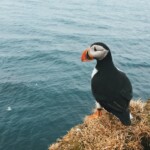
The Látrabjarg cliffs are considered one of the most beautiful places in the Westfjords, making it one of the best places to enjoy hiking in Iceland.
This remote area is one of the best places to see puffins, so you should do this Iceland hiking route if you’re going to be in the area between May and August, the best time to visit Iceland if you want to meet these funny birds. Here, you can also find beautiful flowers and a great wealth of fauna, particularly arctic foxes, and a wide variety of birds.

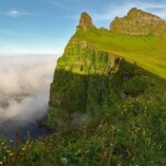
14. Latrabjarg Cliff, a beautiful hike in the Iceland Westfjords
As for the cliffs, not only do they offer spectacular views, but they stand out for their dark color against the mossy greens and sea blues. Without a doubt, it’s one of the most scenic places where you can enjoy the best Icelandic Westfjords hiking.
- Duration: 5 hours
- Distance: 3 miles
- Difficulty: Moderate
- When to go: May-August (puffin season)
- Route type: Out & Back
- Obstacles: Uneven terrain
- Elevation: 1,705 ft
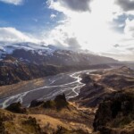
15. Thorsmork Highlights Loop, one of the best hikes in Iceland
I’ve already told you about the two main Iceland hiking routes that pass through Thórsmörk, which are Laugavegur and Fimmvorduhals. However, if you’re looking for a quieter, low-key trail in this area that runs through some remote areas of the Icelandic Highlands, I recommend the Thórsmörk Highlights Loop.
This circular trail connects perfectly with other routes and crosses through forests while giving you beautiful valley and mountain views, including Valahnúkur. If you dare to climb to the top, you’ll be rewarded with incredible panoramic views.

15. Thorsmork Highlights Loop, one of the best hikes in Iceland
Despite the beauty of this walking trail in Iceland, it’s not as popular as the Laugavegur and Fimmvorduhals routes, so it’s much more peaceful. Plus, it’s perfect if you want to visit Thórsmörk in one day.
- Duration: 9-10 hours
- Distance: 6 miles
- Difficulty: Easy
- When to go: May-September
- Route type: Loop
- Obstacles: Uneven terrain
- Elevation: 1,690 ft
Tips for hiking in Iceland
Now that you know the best hiking trails in Iceland, here are some things you should keep in mind to fully enjoy your adventure without any problems. We travel to Iceland every year and have been able to enjoy many hiking trails in this incredible country, so from our experience I recommend the following:
- The weather in Iceland is unpredictable and changes throughout the day, so dress in layers and be prepared for snowstorms, even in summer. I always recommend checking Vedur.is before hiking in Iceland.
- Bring good hiking boots, and try wearing them before you go to Iceland so you can break them in. I don’t suggest wearing brand-new boots on a long hike!
- Download a map of the hiking tour on your smartphone and keep it with you. We use the Maps.me app, one of our favorite apps for traveling since you can us it offline.
- No matter which Iceland hiking route you do, always carry a first aid kit with sterile gauze, wound dressings, blister protectors, elastic bandages, cloth tape, scissors, tweezers, adhesive stitches, disposable gloves, instant cold pack, instant heat gel bag, sanitizer, and a needle and thread. I also recommend bringing a thermal blanket.
- If the route lasts several days, bring enough food and water to last the entire trip, plus one additional day.
- I also suggest bringing a GPS satellite communicator for multi-day hikes. We use the Garmin inReach, which is very useful for reporting emergencies, even in areas with no cell coverage.
- Make sure you have the appropriate vehicle to get to the trail’s starting point. We have a whole article on tips for renting a car in Iceland.
- Double-check which time of year you should do the route, as well as its difficulty, mileage, duration, and obstacles. Before starting any Iceland hiking trail, you should always know its general characteristics.
If you follow these simple tips, you’ll have no problem completing the Iceland routes in this guide. Don’t worry; just because you’re packing a first aid kit and GPS satellite communicator, it doesn’t mean you’ll have to use it. It’s just better to be safe than sorry!
Hiking map of Iceland
Here is the Iceland trail map that I mentioned, which will make it easy for you to locate all the hikes you want to do. Remember to download it in the Maps.me app so you can look at it whenever you need it, even if you don’t have cell service.
Now that you know the best hiking trails in Iceland, all that’s left to do is choose the ones that fit your travel dates and trip duration, as well as your physical abilities. I hope I’ve helped you, and if you have any questions, you can leave me a comment below.
Enjoy your hike through Iceland!


Hi..Are the trails that difficult that it takes over an hour to cover a mile, or are you calculating based on average tourist fitness levels? Thanks
Hey Brian,
Good question! We’re calculating the duration based on the average hiker. Some people might take less time to complete the trails, but we like to give some wiggle room. Plus, you should account for any extra time you’ll spend admiring the views; after all, they’re some of the best hikes in Iceland!
Hope this helps! 🙂