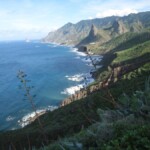
If hiking on Tenerife is something you want to do while you’re on this island, you’re in luck because there are many walking paths for you to enjoy.
During our trip to Tenerife, we were able to do some of the most popular Tenerife hiking routes, and we had a great time exploring the natural surroundings. There are several trails that can take you through laurel forests, beautiful beaches, and impressive ravines, so hiking is one of the best ways to see this Canarian island.
In this guide, I’ll tell you about the best hikes in Tenerife and I’ll share a trail map so you can find one for your fitness level and preferences. Of course, if you want to see all the official walking routes on Tenerife, you can find them on this website.
You can also read through our article on things to do in Tenerife if you want to learn more about the other activities and tourist attractions here.
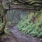
1. Trail of the Senses, one of the most popular hikes on Tenerife
The Trail of the Senses (Sendero de Los Sentidos) is one of the best hikes in Tenerife. It’s in the Anaga Rural Park and is known for being a multi-sensory experience. If you follow the instructions on information boards along the route, you’ll be able to experience Anaga through sight, smell, sound, and touch.

1. Trail of the Senses, one of the most popular hikes on Tenerife
This Tenerife hiking trail consists of three interconnected paths. If you’re short on time or want a simpler route, take Trail 1, which runs along a footbridge to the Cruz del Carmen viewpoint. It’s mostly even terrain and it’s wheelchair friendly. Trail 2 has a dirt road that goes along the laurel forest, and it’s only a bit longer than the first route. Trail 3 is the longest, and it’s perfect for those who want to go through the laurel forest and see the Llano de Los Loros viewpoint.
All three paths start at the parking lot at Cruz del Carmen and pass through the Cruz del Carmen viewpoint. Since they’re interconnected, if you choose Trail 3, you’ll end up doing Trails 1 and 2 as well. You can get a better idea of this circular route by checking out a Tenerife hiking map PDF here.
Trail 1
|
Trail 2
|
Trail 3
|
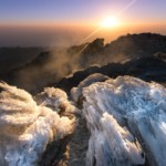
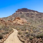
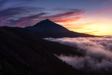
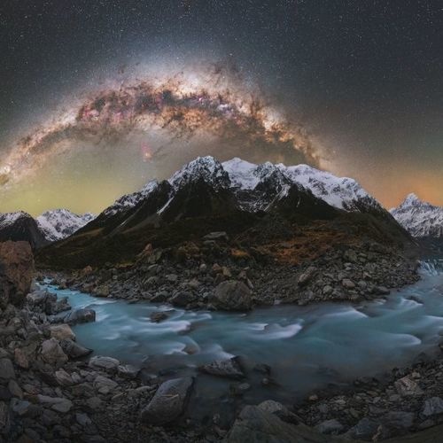
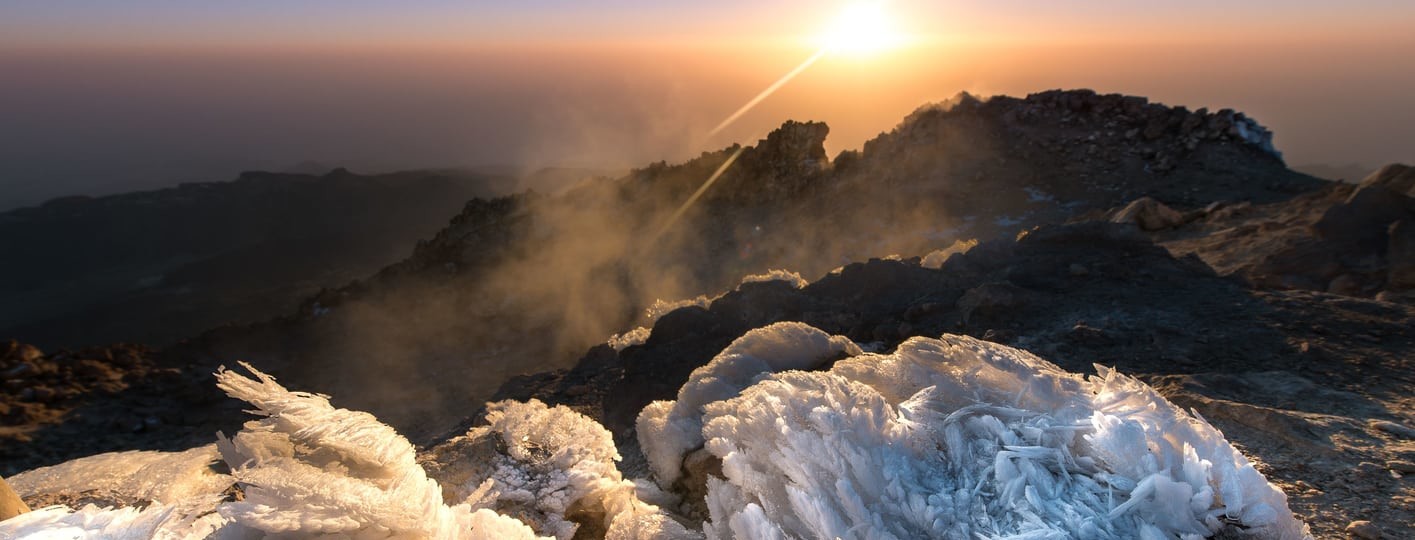
2. Montaña Blanca (Teide Peak), the best hike in Tenerife
Montaña Blanca, or Trail 7, is one of the best places to go hiking on Tenerife because here you can climb Mount Teide.
The route starts at the base of Montaña Blanca and leads to La Rambleta, which is 11,660 feet above sea level and the highest point you can access on Teide without a permit. The hike is about 5 miles long, and the steep trail makes it a difficult route, so you should only do it if you’re in good physical condition or accustomed to mountain hikes. That said, the views and the otherworldly volcanic landscapes make this trail well worth the effort.

2. Montaña Blanca (Teide Peak), the best hike in Tenerife
In addition to Trail 7, you can access La Rambleta via the PR-TF 38 route that passes through Pico Viejo, the second-highest peak on the island. This Tenerife hiking trail is much longer and more complicated.
Once in La Rambleta, I recommend taking Trail 10 or Telesforo Bravo, which goes to the summit of Teide, although you need a permit to access it, which you can request here. If you don’t have this permit, you can take Trail 11 to the La Fortaleza viewpoint, or Trail 12 to the Pico Viejo viewpoint.
Another option for travelers who want to hike Mount Teide on foot is to book this full-day excursion, which includes the permit that gives access to the summit.
- Duration: 5-6 hours (ascent)
- Distance: 5.1 miles
- Difficulty: High
- When to do it: Spring and fall
- Type: One-way
- Obstacles: Steep trail during the ascent
- Elevation gain: 4,470 ft
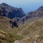
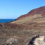
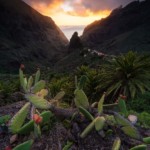
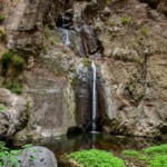
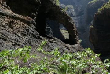
3. Barranco de Masca, the perfect hike in Tenerife
The Barranco de Masca (Masca Gorge) is ideal for travelers who want to enjoy trekking in Masca, Tenerife. This route has been closed for over 3 years and, currently, it’s only accessible on Saturdays, Sundays, and holidays. In addition, there is a daily limit of 125 people in winter and 150 in summer, who enter in groups of 25 every half hour. So, if you want to do this route, you’ll need a permit, which you can request for free on this website.
The trail begins in Caserío de Masca, a remote village wedged between mountains. The highlights of this hike are the descent down the Masca gorge, which leads to Masca Beach, and the ascent back up the ravine.

3. Barranco de Masca, the perfect hike in Tenerife – Efrén Yanes
When we did this route, there was a jetty connecting Masca Beach with Los Gigantes. Unfortunately, it’s not currently open, so you must do the return trip on foot, and this makes it one of the most challenging hikes in Tenerife.
If you intend to do this route, I recommend reading our guide to the Barranco de Masca. Here, you’ll find information about the permit, schedules, requirements, and other useful information about this route.
Alternatively, you can book this guided excursion, so you don’t have to worry about getting the permit.
- Duration: 3-hour descent and 4-hour ascent
- Distance: 3 miles one-way (6 miles round-trip)
- Difficulty: Medium (descent) and high (ascent)
- When to do it: Spring and fall
- Type: Out & Back
- Obstacles: Steep trail during the ascent, slippery terrain
- Elevation gain: 2,460 ft
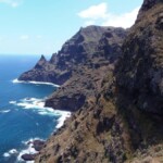
4. Afur – Taganana – Afur (PR-TF 8), another great Tenerife hike
In Anaga you will find numerous trails, but the one that goes from Afur to Taganana is one of the most beautiful circular hikes in Tenerife, as it takes you through laurel forests and between cliffs.
The route begins in Afur, a small mountain town of fewer than 100 inhabitants. Here, you’ll find the path that enters the Anaga mountains and goes toward Taganana, a historical area with amazing architecture.

4. Afur – Taganana – Afur (PR-TF 8), another great Tenerife hike
One of the points of interest along this route is Tamadite Beach, which is one of the best beaches in Tenerife thanks to the surrounding cliffs that create a striking coastline. However, keep in mind that swimming is not allowed on this beach since there are usually strong currents. Another interesting point is the lookout point at Los Roques de Anaga, where you can see the cliffs and the Atlantic Ocean.
Without a doubt, this is one of the best hikes in Anaga, Tenerife that allows you to discover some of the island’s distinct natural landscapes. Plus, you’ll get to see the iconic towns of Afur and Taganana.
- Duration: 5-6 hours
- Distance: 7.5 miles
- Difficulty: Medium
- When to do it: Year-round
- Type: Loop
- Obstacles: Ascent/descent along the ravine to Tamadite Beach
- Elevation gain: 2,260 ft
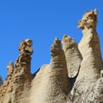
5. Vilaflor, one of the south Tenerife hiking routes you must do
One of the most spectacular hiking trails in Tenerife starts from the town of Vilaflor and is known as the Lunar Landscape.
It’s one of the oldest trails in Tenerife and is part of the Camino Real de Chasna, a path that the Guanches used more than 500 years ago to travel across the island. These days, the route is less for going from one end of the island to the other, but more for crossing the Lunar Landscape.

5. Vilaflor, one of the south Tenerife hiking routes you must do
This south Tenerife hiking path goes through a Canarian pine forest and leads to one of the most stunning areas on the island. The Lunar Landscape is home to several large stone figures that, over time, have eroded and formed peculiar shapes. They’re on an incline and almost look like a work of contemporary art. As the name suggests, if you visit this place, you’ll feel like you’ve traveled to the moon!
The trail has plenty of signposts, so just follow them to Los Escurriales, where you’ll find this unique sight. It’s certainly one of the best hiking trails in Tenerife if you’re in the southern part of the island and want a quiet route.
- Duration: 4 hours
- Distance: 6 miles
- Difficulty: Medium
- When to do it: Year-round
- Type: Loop
- Obstacles: Mountains
- Elevation gain: 1,410 ft
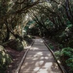
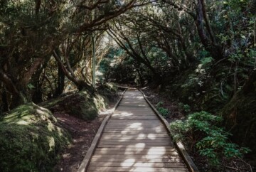
6. Bosque de los Enigmas, the best hiking on Tenerife for families
“The Enchanted Forest” is in Anaga Rural Park and is one of the best Tenerife hikes to do with kids.

6. Bosque de los Enigmas, the best hiking on Tenerife for families
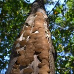
This easy walk is a great way to learn more about the park and its origins, as well as see the laurel forests, which are one of the island’s main attractions. Along the path, you’ll find interpretative boards describing the flora and mysteries of the forest. Surely, it’s a fantastic place for hiking on Tenerife where you can disconnect and enjoy the natural beauty.
The trail begins at the Zapata viewpoint or the Cruz del Carmen Visitor Center. You can also book this guided tour, which will take you through the forest and teach you more about its history.
- Duration: 2 hours
- Distance: 3.5 miles
- Difficulty: Low
- When to do it: Year-round
- Type: Loop
- Obstacles: Steep trail and slippery areas
- Elevation gain: 30 ft
7. Barranco del Infierno, a top south Tenerife hiking spot
The Barranco del Infierno, or Hell’s Gorge, has some of the best hiking in south Tenerife. This well-known area was declared a Special Natural Reserve, so access is limited to 300 people a day to protect and preserve the animal and plant species, some of which only live here. So, if you want to do this hike, you must reserve a ticket on this website.

7. Barranco del Infierno, a top south Tenerife hiking spot
This route is in Adeje and begins at the highest point of Calle de Los Molinos. From there, you must follow a path that was once used by shepherds, which leads to some gorgeous panoramic viewpoints. As you advance along the path and walk along the bed of the ravine, the path narrows, which makes it one of the most impressive Tenerife hiking trails.
During the walk, I suggest you keep your eyes peeled for hawks, crows, kestrels, and Cinderella shearwaters, which live on the island permanently.
Also, if you’d prefer a guided tour, you can book this one, which includes the ticket to Barranco del Infierno.
- Duration: 3-4 hours
- Distance: 5 miles
- Difficulty: Medium
- When to do it: Year-round
- Type: Out & Back
- Obstacles: The terrain can be slippery
- Elevation gain: 3,250 ft
8. Siete Cañadas, a beautiful place for trekking in Tenerife
Another great place for trekking in Tenerife is at Siete Cañadas, which is part of the old Camino de Chasna, the road that linked the north and south of the island.
Las Cañadas is in Teide National Park, and it’s an area that accumulated natural materials after the volcanic eruptions. Despite its desert appearance, Las Cañadas is one of the most geologically interesting places on the island. If you decide to do this route, which is also one of the longest Tenerife hikes, you’ll be able to see this area up close.

8. Siete Cañadas, a beautiful place for trekking in Tenerife
The trail starts at the Parador de Las Cañadas del Teide and boasts incredible views from start to finish. The best time to hike this route is in June, which is when you can see the tajinaste rojo, or tower of jewels, blossom. However, even if you hike this Tenerife trail later in the year, you’ll still see amazing geological formations, like the Roque del Capricho.
- Duration: 4-5 hours
- Distance: 10 miles
- Difficulty: Medium
- When to do it: Spring and fall
- Type: Out & Back
- Obstacles: Extreme temperatures in summer and winter
- Elevation gain: 1,312 ft
9. Hike to Mount Guajara, another amazing trail in Tenerife
The Guajara trail is another hike in Tenerife that you should do, especially because it goes to the third-highest peak on the island.
As a curiosity, Mount Guajara is quite a historical place and is named after a Guanche princess who jumped to her death after discovering that her lover had died on the battlefield.

9. Hike to Mount Guajara, another amazing trail in Tenerife
The route leading to the summit offers beautiful views, especially in May and June when the plants and flowers have blossomed. Some of the species you can see here include daisies, broom, laburnum, pajonera grass, and tajinaste. The landscape alone makes it one of the best places for hiking on Tenerife, although the summit is a beauty in itself. From this peak, you’ll get lovely 360° views of Mount Teide, the Roques de García, Pico Viejo, Montaña Blanca, Montaña Rajada, and Teide National Park.
- Duration: 4 hours
- Distance: 2 miles
- Difficulty: Medium
- When to do it: Spring and fall
- Type: Loop
- Obstacles: Extreme temperatures in summer and winter
- Elevation gain: 2,525 ft
10. Teno, the best hiking in Tenerife’s laurel forest
Teno Rural Park is considered one of the most magnificent natural areas in Tenerife, especially for its cliffs and laurel forests. So, if you’re looking for places to go hiking in north Tenerife, one of the best options is Teno. This hike will take you through much of Teno Rural Park, and it’ll pass through Buenavista del Norte and Los Silos.

10. Teno, the best hiking in Tenerife’s laurel forest
The trail’s starting point is Las Portelas in the El Palmar valley. From there, you follow the path into the lovely laurel forest until you reach Pajales Viejos. You’ll also get to see the houses on the summit and the bluffs of Martín Bay, from which you can enjoy views of the old volcanic massif of Teno. One of the highlights of this mountain is the Barranco de Masca, although you can see other ravines like Los Carrizales. On clear days, you can even see the islands of La Gomera and La Palma.
You’ll see all these sights before getting to La Cancela, and then you’ll return back to Las Portelas. Overall, it’s an excellent circular hiking trail in Tenerife, and a great way to see a variety of plant and animal species. For example, Teno Rural Park is home to laurel, holly, buckthorn, bluebells, crow’s foot, laurel pigeons, and turquoise pigeons.
- Duration: 5-6 hours
- Distance: 7.1 miles
- Difficulty: Medium
- When to do it: Year-round
- Type: Loop
- Obstacles: Steep trail
- Elevation gain: 1,837 ft
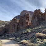
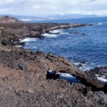
11. Roques de García, one of the best circular hikes in Tenerife
The route that circles the Roques de García is one of the best places for hiking in Teide, Tenerife. On this trail, you can see the peculiar rock formations, which were created by years of erosion, up close.

11. Roques de García, one of the best circular hikes in Tenerife – Efrén Yanes
This Tenerife hiking trail is very interesting since it’s in Teide National Park. Not only that, but it’s the best circular route if you’re short on time and want to see the Roques de García. The path starts at La Ruleta viewpoint and continues to the impressive rocks, including Roque Cinchado, Torrotito, El Burro, and Los Roques Blancos.
These rocky structures aren’t the only attractions on this route. You’ll also see lava flows like La Cascada, as well as a volcanic formation known as The Cathedral, thanks to its distinct shape. Without a doubt, this is one of the best hikes in Tenerife if you’re interested in the island’s volcanic activity. Moreover, depending on when you do this hike, you can see the tajinaste and other plant species in full bloom.
- Duration: 2 hours
- Distance: 2.1 miles
- Difficulty: Low
- When to do it: Spring and fall
- Type: Loop
- Obstacles: Extreme temperatures in summer and winter
- Elevation gain: 595 ft
12. Malpaís de Güímar, an easy Tenerife hiking trail
Malpaís de Güímar is another area that was declared a Special Natural Reserve, so if you’re looking for a beautiful place for an easy hike in north Tenerife, I recommend going here.
The route starts at the Puertito de Güímar before entering the natural reserve, which became a protected area in 1987. Right away, you’ll notice that the scenery of Malpaís de Güímar looks like something out of a fantasy film. It’s practically a desert, but there is also red sand and dark, solidified lava.

12. Malpaís de Güímar, an easy Tenerife hiking trail
Along this trail, you’ll find otherworldly landscapes, including lava tubes and volcanic caves like Cueva Honda. There are also a few viewpoints offering impressive panoramas of the region, so it’s one of the best hiking trails in Tenerife to explore nature. Moreover, even though Malpaís de Güímar resembles a desert, there is also vegetation, such as tabaiba plants and giant cardón cacti growing between the lava cracks.
Also, if you’re looking for hikes in Tenerife to do with kids, this is one of the best options since the terrain is mostly flat.
- Duration: 4 hours
- Distance: 5.1 miles
- Difficulty: Low
- When to do it: Spring and fall
- Type: Loop
- Obstacles: Extreme temperatures in summer and winter
- Elevation gain: 510 ft
13. Guardianes Centenarios, one of the most beautiful hiking trails in Tenerife
The Centennial Guardians trail is another lovely place to go hiking in Tenerife, especially since the scenery looks like something out of a fairytale. This trail is in the town of Agua García, in Tacoronte, within the Agua García forest.
The name of this Tenerife hiking route refers to the great viñátigo trees, a type of evergreen, and they’re believed to be 800 years old. It is said that the trees serve as guardians of all the animals in the forest and the plants that grow around the trees’ roots, such as laurels, heather, fayas, and lime trees.

13. Guardianes Centenarios, one of the most beautiful hiking trails in Tenerife
The Centennial Guardians trail starts at the Agua García Heritage Information Center. From there, the landscape transforms into a laurel forest with bridges, caves, and, sometimes, a mist that makes the place even more magical.
Without a doubt, it’s one of the most stunning hikes in Tenerife. Many travelers like to compare it with the trails in Anaga Rural Park, but this route is one-of-a-kind.
- Duration: 3 hours
- Distance: 3.1 miles
- Difficulty: Low
- When to do it: Year-round
- Type: Loop
- Obstacles: None
- Elevation gain: 950 ft
14. Cruz del Carmen – Punta del Hidalgo (PR-TF 10), another fun hiking route in Tenerife
Many of Tenerife’s best hikes are in or around Anaga Rural Park, such as the one that connects Cruz del Carmen and Punta del Hidalgo.
This walking route starts at the Cruz del Carmen restaurant. From there, you’ll make your descent towards Las Carboneras before heading to Chimanada and finally, Punta del Hidalgo.

14. Cruz del Carmen – Punta del Hidalgo (PR-TF 10), another fun hiking route in Tenerife
There are three distinct sections along this Tenerife walking trail, the first being the characteristic Canarian laurel forest. When you reach the second section, the scenery becomes agricultural and open, while the third section involves descending down the steep and bushy coast of north Tenerife. So, if you want to experience a few different landscapes on the island, this is the route for you.
- Duration: 4 hours
- Distance: 6.8 miles
- Difficulty: Medium
- When to do it: Year-round
- Type: Out & Back
- Obstacles: Much of the route is downhill and there are stone paths, so it’s easy to slip
- Elevation gain: 1,970 ft
15. Ascent to Montaña Roja, some of the best hiking in south Tenerife
If you love hiking in the mountains, then consider climbing Montaña Roja. This route is one of the best hikes in south Tenerife.
The Red Mountain was declared a Special Natural Reserve since several unique plant and animal species live in this area, particularly rare bird species. The mountain is also home to protected geological elements, which you can see during your trek.

15. Ascent to Montaña Roja, some of the best hiking in south Tenerife
Unlike other mountain routes, this one is quite simple and doesn’t require great physical effort. You’ll depart from either El Médano, La Tejita Beach, or the parking lot between El Médano and Los Abrigos, then make your way to the path leading to the mountaintop. It doesn’t matter which trail you choose since they each provide sweeping views of the landscape.
Once you get to the top, you can look out over La Tejita Beach, El Confital Beach, and the town of Los Abrigos. Plus, you’ll get panoramic views of the area surrounding the Red Mountain, which is all volcanic land and very impressive. It’s one of the most enjoyable places for hiking on Tenerife’s southern coast, as well as one of the most interesting in terms of flora, fauna, and geology.
- Duration: 2-3 hours
- Distance: 2.8 miles
- Difficulty: Low
- When to do it: Spring and fall
- Type: Loop
- Obstacles: Extreme temperatures in summer and winter
- Elevation gain: 525 ft
Tenerife hiking map
Here is a map of the Tenerife hiking trails I mentioned to help you organize your trip and decide which routes to take.
I recommend you keep this Tenerife trails map handy since it will make it much easier for you to find each route’s starting point, as well as the main attractions on each hike.
Finally, if you have any questions, feel free to leave me a comment below so I can help you out. I hope you enjoy hiking on Tenerife!